mail_outline sales@mediastorehouse.com
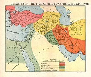
Dynasties in the time of the Buwayids, circa 932 A. D. c1915. Creator: Emery Walker LtdDynasties in the time of the Buwayids, circa 932 A.D. c1915. Map of civilisations in the Middle East during the 10th century: Byzantine, Buwayid Kingdom, Abbasid Caliphate, Kingdom of the Ikhshids
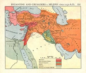
Byzantine and Crusaders v. Seljuks, circa 1130 A. D. c1915. Creator: Emery Walker LtdByzantine and Crusaders v. Seljuks, circa 1130 A.D. c1915. Map of civilisations in the Middle East during the 12th century: Byzantine, other Christian states, Abbasid Caliphate, Seljuks, Fatimids
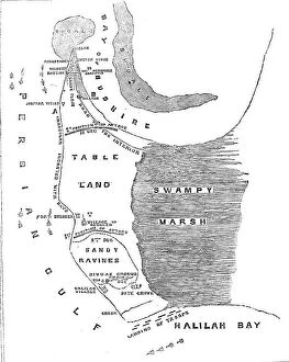
Plan of the Operations against Bushire, 1857. Creator: UnknownPlan of the Operations against Bushire, 1857. Map showing Persian Gulf, tableland, sandy ravines, swampy marsh, Halilah Bay
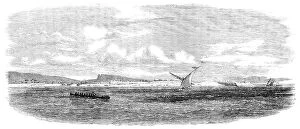
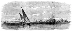
Bunder Deelum, in the Persian Gulf, 1857. Creator: UnknownBunder Deelum, in the Persian Gulf, 1857. The accompanying view of one of the numerous forts in the Persian Gulf has been sketched from the deck of the Hon
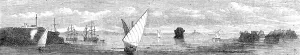
The Island of Karrak, in the Persian Gulf, 1857. Creator: UnknownThe Island of Karrak, in the Persian Gulf, 1857. Engraving after a sketch by Mr. A. Harrison, Master, Indian Navy...The Island of Karrak...is situated thirty miles W.N.W
Sketches in the Persian Gulf - Margill, the Residence of the British Consul, near Bussorah, 1857. Creator: UnknownSketches in the Persian Gulf - Margill, the Residence of the British Consul, near Bussorah, [Basra], 1857. Engraving after a sketch by an officer belonging to the expeditionary force...Margill...is
The Persian Expedition - H.E.I.C. "Semiramis", Bushire, Resident's House, Sandbag Batteries, 1857The Persian Expedition - H.E.I.C. [Honourable East India Company] "Semiramis", Bushire, Resident's House, Sandbag Batteries, 1857
The Persian Expedition - Transports, Bushire, from the "Semiramis", Fort for defence... 1857The Persian Expedition - Transports, Bushire, from the "Semiramis", Fort for defence of Water Tanks, 1857. Sketch...by an officer, in the Bushire Roads
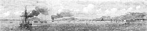
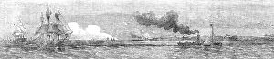
The Persian Expedition - the "Abdulla" Transport, the "Feroze", "Punjaub", and "Assaye" shelling the Old Portuguese Battery, Indus Flat, 1857
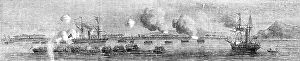
The Persian Expedition - 64th Regiment and Bombay (4th) Rifles, the "Bombay" Steamer... 1857The Persian Expedition - 64th Regiment and Bombay (4th) Rifles, the "Bombay" Steamer aground, Gun-boats, the "Sir Jamsetjee Jejeebhoy", Hallilah Hill, 1857
The Persian Expedition - Island of Kishni, Entrance to Clarence Strait (from the "Semiramis"), 1857. Sketch...by an officer, in the Bushire Roads
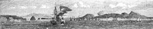
The Persian Expedition - Island of Kishni, Harbour of Bunder Abbas, Fleet at Anchor, Persian...1857. Creator: UnknownThe Persian Expedition - Island of Kishni, Harbour of Bunder [Bandar] Abbas, Fleet at Anchor, Persian Coast, 1857. Sketch...by an officer, in the Bushire Roads
The Persian Expedition - Minora Point and Lighthouse, Kurrachee Harbour, Oyster Rock... 1857. Creator: UnknownThe Persian Expedition - Minora Point and Lighthouse, Kurrachee [Karachi] Harbour, Oyster Rock, Church and Town of Kurrachee, Oyster Rocks, 1857
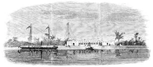
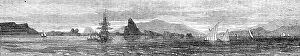
Bassadore, the British Station and Depot, in the Persian Gulf - from a sketch by an officer of the Indian Navy, 1857. A...general View of Bassadore
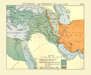
Ottoman and Persian, after 1450 A. D. c1915. Creator: Emery Walker LtdOttoman and Persian, after 1450 A.D. c1915. Map of empires in the Middle East during the 15th-17th centuries: Ottoman Empire at the accession of Mohammed II, 1451 AD, Additions 1481-1683
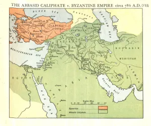
The Abbasid Caliphate v. Byzantine Empire, circa 786 A. D. c1915. Creator: Emery Walker LtdThe Abbasid Caliphate v. Byzantine Empire, circa 786 A.D. c1915. Map of civilisations in the Middle East during the 8th century, and also showing the eastern Mediterranean, Red Sea, Caspian Sea
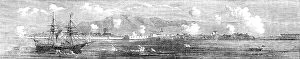
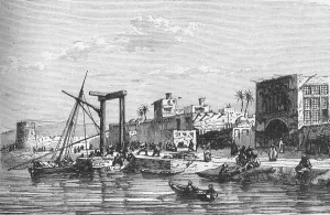
View of the Fort of Bushire, c1891. Creator: James GrantView of the Fort of Bushire, c1891. From " Cassells Illustrated History of India Vol. II.", by James Grant. [Cassell Petter & Galpin, London, Paris and New York]
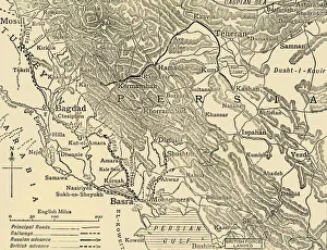
Bagdad and the Persian Campaign, First World War, end of April 1916, (c1920). Creator: UnknownBagdad and the Persian Campaign, First World War, end of April 1916, (c1920)....map showing approximately the lines of the British advance from the Persian Gulf
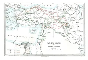
Authors Routes in Asiatic Turkey, c1915. Creator: Stanfords Geographical EstablishmentAuthors Routes in Asiatic Turkey, c1915. Map showing the journeys of British writer, soldier and diplomatic advisor Mark Sykes (1879-1919) who travelled through Palestine, Iraq, Syria
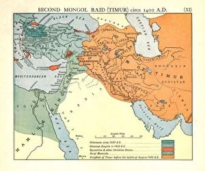
Second Mongol Raid (Timur), circa 1450 A. D. c1915. Creator: Emery Walker LtdSecond Mongol Raid (Timur), circa 1450 A.D. c1915. Map of civilisations in the Middle East during the 14th and 15th centuries: Ottomans c1350 AD, Ottoman Empire in 1400 AD
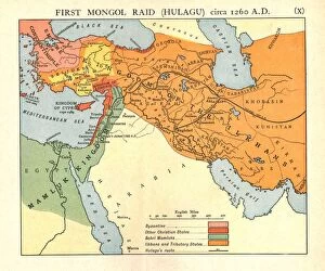
First Mongol Raid (Hulagu), circa 1400 A. D. c1915. Creator: Emery Walker LtdFirst Mongol Raid (Hulagu), circa 1400 A.D. c1915. Map of civilisations in the Middle East during the early 15th century: Byzantine, other Christian states, Bahri Mamluks
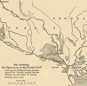
Map illustrating the Operations in the Persian Gulf, First World War, 1915, (c1920)....showing the British oil pipe guarded against the Turkish attacks and the advance up the Tigris to Amara