mail_outline sales@mediastorehouse.com
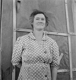
Mrs. Cleaver is raising five sons on new farm, Malheur County, Oregon, 1939. Creator: Dorothea LangeMrs. Cleaver is raising five sons on new farm. Malheur County, Oregon
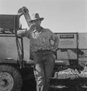
George Cleaver who is trying to develop 177 acres of raw land, Malheur County, Oregon, 1939. Creator: Dorothea LangeGeorge Cleaver who is trying to develop 177 acres of raw land. He has five sons. Malheur County, Oregon
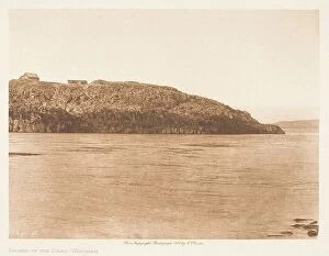
Island of the Dead Wisham, From The North American Indian by Edward S. Curtis. 1909. Creator: Edward Sheriff CurtisIsland of the Dead Wisham, From The North American Indian by Edward S. Curtis. 1909
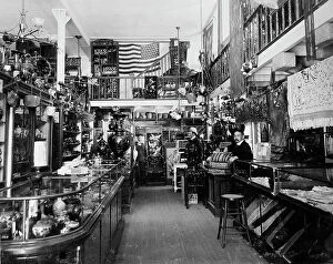
Andrew Kan & Co. china store, Portland, Ore. between 1895 and 1910. Creator: Unknown. Andrew Kan & CoAndrew Kan & Co. china store, Portland, Ore. between 1895 and 1910
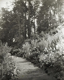
"High Hatch, " Thomas Kerr garden, SW Military Lane, Portland, Oregon, 1923
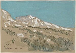
Mount Hood, Oregon, 1904. Creator: Frederick Childe HassamMount Hood, Oregon, 1904
Farm Security Administration camp, Klamath Falls, Oregon, 1941. Creator: Dorothea LangeFarm Security Administration camp. Klamath Falls, Oregon
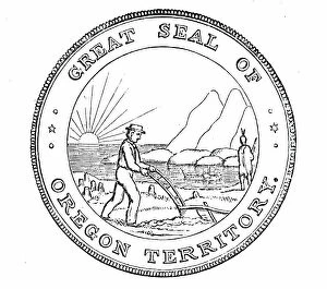
The Great Seal of Oregon, 1850. Creator: UnknownThe Great Seal of Oregon, 1850. The design represents the mouth of the Columbia river, and beyond is the Pacific Ocean; in the foreground is a man ploughing
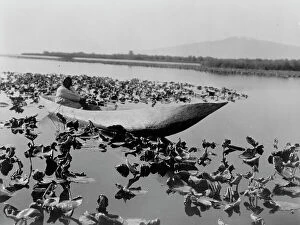
The wokas season-Klamath, c1923. Creator: Edward Sheriff CurtisThe wokas season-Klamath, c1923. Photograph shows a Klamath woman in a dugout canoe resting in a field of wokas, or great yellow water lilies (nymphaea polysepala) used as food
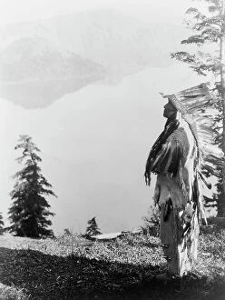
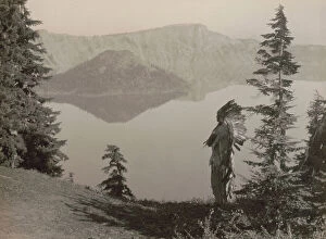
Praying to the Spirits at Crater Lake-Klamath, c1923. Creator: Edward Sheriff CurtisPraying to the Spirits at Crater Lake-Klamath, c1923. Klamath Indian chief in feather headdress standing on mountain overlooking Crater Lake, Oregon
Crater Lake, 1923 Creator: Edward Sheriff CurtisCrater Lake, 1923 Photograph shows an American Indian man wearing a headress, seated on a rock overlocking Crater Lake, Oregon
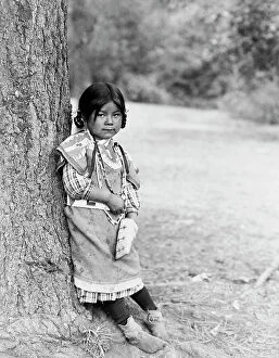
Innocence, an Umatilla girl, full-length portrait, standing by tree, facing slightly right, c1910
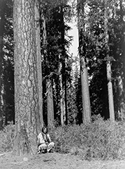
In the forest-Klamath, c1923. Creator: Edward Sheriff CurtisIn the forest-Klamath, c1923. Photograph shows a Klamath man in traditional dress squatting next to an enormous tree in a forest of Ponderosa Pines, probably in the Klamath Basin in Oregon
The chief-Klamath, c1923. Creator: Edward Sheriff CurtisThe chief-Klamath, c1923. Photograph shows Klamath Indian chief in ceremonial headdress standing on hill overlooking Crater Lake, Oregon
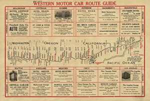
Western motor car route guide, (1915?). Creator: UnknownWestern motor car route guide, (1915?). This automobile guide shows the main highway route between Vancouver, Canada, and San Diego, California, circa 1915
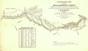
Topographical map of the road from Missouri to Oregon, commencing at the mouth of the Kansas...1846 CreatorsTopographical map of the road from Missouri to Oregon, commencing at the mouth of the Kansas in the Missouri River and ending at the mouth of the Walla-Wallah in the Columbia, 1846
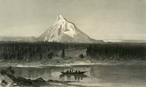
Mount Hood, from the Columbia, 1872. Creator: Robert HinshelwoodMount Hood, from the Columbia, 1872. View of the Columbia River and Mount Hood, a potentially active stratovolcano in Oregon, north western USA
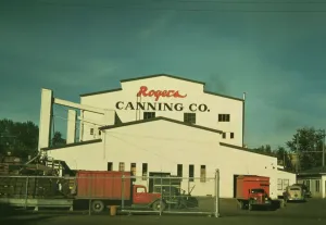
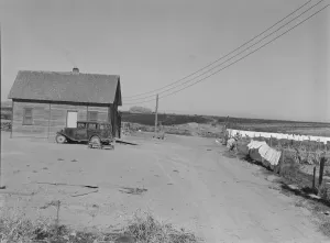
Canning plant where peas are principal project, Milton-Freewater, Oregon, 1941. Creator: Russell LeeCanning plant where peas are principal project, Milton-Freewater, Oregon. [Sign: Rogers Canning Co.]
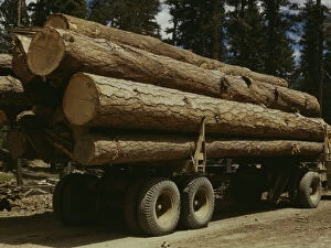
Truck load of ponderosa pine, Edward Hines Lumber Co. operations... Grant County, Oregon, 1942. Creator: Russell LeeTruck load of ponderosa pine, Edward Hines Lumber Co. operations in Malheur National Forest, Grant County, Oregon
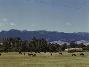
Horse breeding ranch, Grant Co. Oregon, 1942. Creator: Russell LeeHorse breeding ranch, Grant Co. Oregon
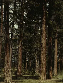
Stand of virgin ponderosa pine, Malheur National Forest, Grant County, Oregon, 1942. Creator: Russell LeeStand of virgin ponderosa pine, Malheur National Forest, Grant County, Oregon
[Hop pickers camp?], 1939. Creator: Dorothea Lange[Hop pickers camp?], 1939
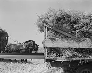
One of the eight cooperating farmers drive loaded wagons to the silo, Yamhill County, Oregon, 1939One of the eight cooperating farmers drive loaded wagons to the silo. Yamhill County, Oregon
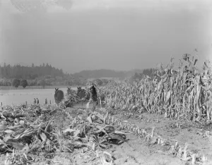
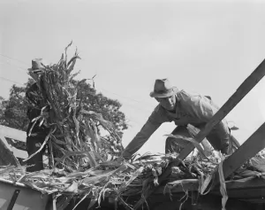
Cutting the corn on the Miller farm near West Carlton, Yamhill County, Oregon, 1939. Creator: Dorothea LangeCutting the corn on the Miller farm near West Carlton, Yamhill County, Oregon
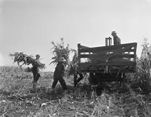
Cooperating farmers load wagons with corn... Yamhill County, Oregon, 1939. Creator: Dorothea LangeCooperating farmers load wagons with corn. One of the eight cooperating farmers drive loaded wagons to the silo. Yamhill County, Oregon
Potato cellar in the Klamath Basin... Merrill, Klamath County, Oregon, 1939. Creator: Dorothea LangePotato cellar in the Klamath Basin in which 4000 one hundred-pound sacks will be stored. Merrill, Klamath County, Oregon
Entering Cow Hollow region in which practically all are FSA borrowers, Malheur County, Oregon, 1939Entering Cow Hollow region in which practically all are FSA (Farm Security Administration) borrowers. These are farmers who had a late start. Malheur County, Oregon
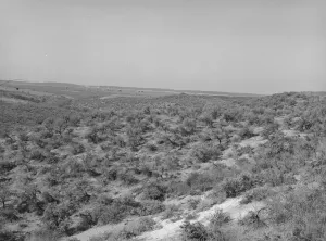
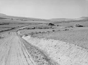
Landscape showing raw land, Nyssa Heights, Malheur County, Oregon, 1939. Creator: Dorothea LangeLandscape showing raw land. Nyssa Heights, Malheur County, Oregon
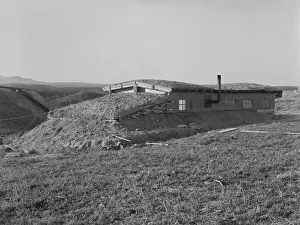
The Schroeder familys new house, Dead Ox Flat, Malheur County, Oregon, 1939. Creator: Dorothea LangeThe Schroeder familys new house. Cleared and irrigated fields of their land beyond. Dead Ox Flat, Malheur County, Oregon
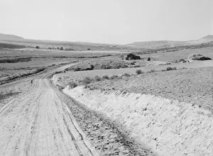
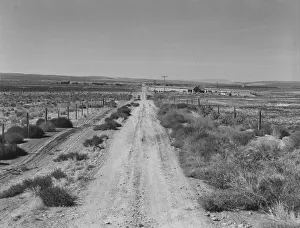
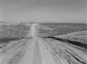
Section of lone road approaching the Schroeder place, Dead Ox Flat, Malheur County, Oregon, 1939Section of lone road approaching the Schroeder place. Dead Ox Flat, Malheur County, Oregon
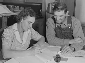
Wife of FSA borrower keeps account of loan of... Dead Ox Flat, Malheur County, Oregon, 1939. Creator: Dorothea LangeWife of FSA (Farm Security Administration) borrower keeps account of loan of seven hundred and forty-eight dollars. Dead Ox Flat, Malheur County, Oregon
FSA borrowers on new farm keep account of their loan, Dead Ox Flat, Malheur County, Oregon, 1939Farm Security Administration borrowers on new farm keep account of their loan. Dead Ox Flat, Malheur County, Oregon
Entering Cow Hollow region... all are FSA borrowers, Malheur County, Oregon, 1939. Creator: Dorothea LangeEntering Cow Hollow region in which practically all are FSA (Farm Security Administration) borrowers. These are farmers who had a late start. Malheur County, Oregon
One of the younger Cleaver boys on new farm in Malheur County, Oregon, 1939. Creator: Dorothea LangeOne of the younger Cleaver boys on new farm in Malheur County, Oregon
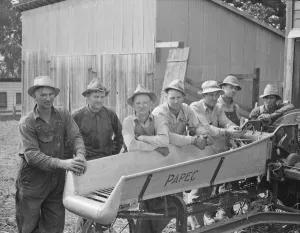
Seven of the eight farmers shown with their coop... West Carlton, Yamhill County, Oregon, 1939. Creator: Dorothea LangeSeven of the eight farmers shown with their cooperatively owned ensilage cutter on the Miller farm, where they are working filling the silo. West Carlton, Yamhill County, Oregon
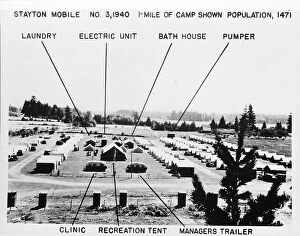
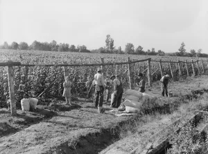
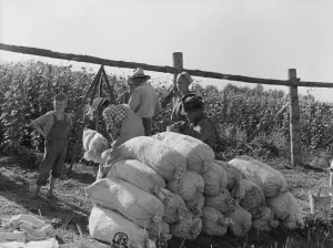
Weighting scales at edge of bean field, near West Stayton, Marion County, Oregon, 1939. Creator: Dorothea LangeWeighting scales at edge of bean field. Near West Stayton, Marion County, Oregon
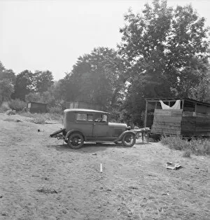
One of a dozen or more small bean pickers camps in immediate... near West Stayton, Oregon, 1939One of a dozen or more small bean pickers camps in immediate vicinity. Near West Stayton, Oregon
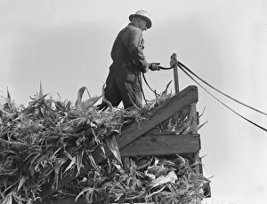
Cooperating farmers with wagonload of corn... Yamhill County, Oregon, 1939. Creator: Dorothea LangeCooperating farmers with wagonload of corn. Feeding corn from the wagon through the ensilage cutter from which it is blown thru the pipe into the silo. Yamhill County, Oregon
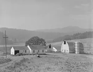
Unit no. 32 of Yamhill farms, Oregon, 1939. Creator: Dorothea LangeUnit no. 32 of Yamhill farms, Oregon: sewage disposal, electrification, twelve-cow dairy barn, silo under construction and five-room house
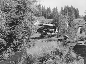
Wide view of the first mobile camp unit (FSA), situated in the Klamath Basin, Oregon, 1939. Creator: Dorothea LangeWide view of the first mobile camp unit (FSA - Farm Security Administration), situated in the Klamath Basin, Oregon. [Note male and female showers in trailers on left]
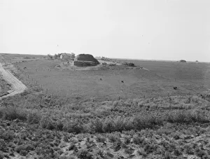
View of newly reclaimed bench land, Dead Ox Flat, Malheur County, Oregon, 1939. Creator: Dorothea LangeView of newly reclaimed bench land. Emmett Smith (farm in background), " took his place out of the bush 3 years ago." Dead Ox Flat, Malheur County, Oregon
Landscape showing home of FSA borrower... Nyssa Heights, Malheur County, Oregon, 1939. Creator: Dorothea LangeLandscape showing home of FSA (Farm Security Administration) borrower: sage bush, hayfield, farmstead, and cattle in pasture. Nyssa Heights, Malheur County, Oregon
The Daugherty home, Warm Springs district, Malheur County, Oregon, 1939. Creator: Dorothea LangeThe Daugherty [or Dougherty] home. Note siphon which brings irrigation water from the opposite bench. Warm Springs district, Malheur County, Oregon
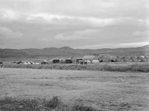
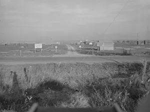
Entrance to Nyssa Farm family labor camp, FSA mobile unit... 1, Near Nyssa, Oregon, 1939. Creator: Dorothea LangeEntrance to Nyssa Farm family labor camp, FSA (Farm Security Administration) mobile unit number 1, just established before opening of beet season. Near Nyssa, Oregon. [Signs: United States Dept
Threshing, midsummer noon. Five miles west of Malin. Klamath County, Oregon, 1939. Creator: Dorothea LangeThreshing, midsummer noon. Five miles west of Malin. Klamath County, Oregon
Beanfield - weigh scales, pickers, and sacked beans at edge of... near West Stayton, Oregon, 1939Beanfield. Weigh scales, pickers, and sacked beans at edge of field. Near West Stayton, Marion County, Oregon
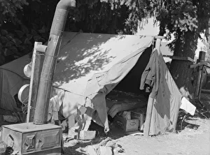
Bean pickers tent, one of fourteen in a group... near West Stayton Marion County, Oregon, 1939. Creator: Dorothea LangeBean pickers tent, one of fourteen in a group on growers property, adjoining the bean field. Near West Stayton Marion County, Oregon
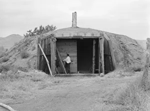
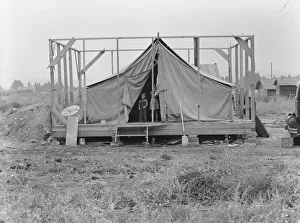
Family living in tent while building the house... near Klamath Falls, Klamath County, Oregon, 1939Family living in tent while building the house around them. Near Klamath Falls, Klamath County, Oregon