mail_outline sales@mediastorehouse.com
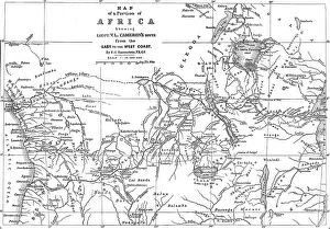
Map of a Portion of Africa, showing...Cameron's Route from the East to the West Coast...1876Map of a Portion of Africa, showing Lieut. V.L. Cameron's Route from the East to the West Coast, 1876. A Map of the entire width of Africa
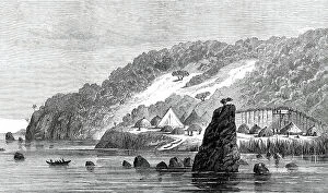
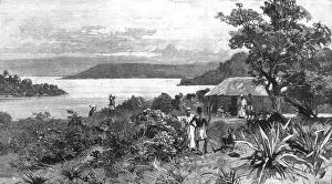
Sketches by Lieutenant Cameron in Central Africa: Kituta Village, Lake Tanganyika, 1876. Creator: UnknownSketches by Lieutenant Cameron in Central Africa: Kituta Village, Lake Tanganyika, 1876. View of...the native village of Kitata, on the eastern shore, about half-way down the lake from Ujiji
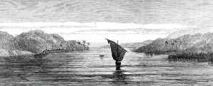
Sketches by Lieutenant Cameron in Central Africa...Lukuga Outlet of Lake Tanganyika...1876. Creator: UnknownSketches by Lieutenant Cameron in Central Africa: entrance to the Lukuga Outlet of Lake Tanganyika, 1876. Lieutenant Cameron's more exact survey led to the discovery of an important outlet
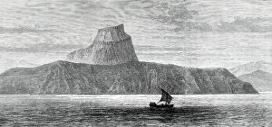
Sketches by Lieutenant Cameron in Central Africa: Malumbi Hill, Lake Tanganyika, 1876. Creator: UnknownSketches by Lieutenant Cameron in Central Africa: Malumbi Hill, Lake Tanganyika, 1876. On the opposite or western shore of the lake, a conspicuous object is the lofty flat-topped hill of Malumbwi
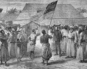
'Practical Civilising Work in Central Africa; Kavala Island on Lake Tanganyika, 1890. Creator: UnknownPractical Civilising Work in Central Africa; Kavala Island on Lake Tanganyika, 1890. From "The Graphic. An Illustrated Weekly Newspaper", Volume 41. January to June, 1890
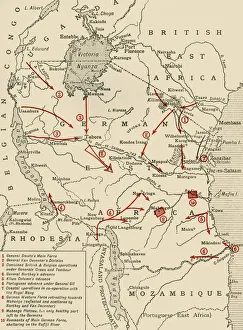
Colonial possessions in East Africa during the First World War, c1916, (c1920). Creator: UnknownColonial possessions in East Africa during the First World War, c1916, (c1920). Map showing German East Africa, British East Africa, the Belgian Congo, Rhodesia, Uganda
Map of East Africa, First World War, (c1920). Creator: John Bartholomew & SonMap of East Africa, First World War, (c1920). Map showing colonial possessions including the Belgian Congo, British East Africa, German East Africa, Northern Rhodesia and Portuguese East Africa
Stanley s... Meeting with Emin Pasha, April 29, 1888, at Kavalli... (1901). Creator: UnknownStanleys Journey through Unknown Central Africa, 1887-1890: His Meeting with Emin Pasha, April 29, 1888, at Kavalli, on Lake Nyanza, (1901)
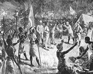
Livingstone... : The Great Missionary-Explorer found by Stanley, 1870, (1901). Creator: UnknownLivingstones Exploration of Lake Tanganyika: The Great Missionary-Explorer found by Stanley, 1870, at Ujiji, (1901). The historic meeting between Henry Morton Stanley (1841-1904)