mail_outline sales@mediastorehouse.com
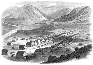
Sketches from British Columbia: Lilloett, on the Fraser River, 1864. Creator: UnknownSketches from British Columbia: Lilloett, on the Fraser River, 1864. '...a bird's-eye view, of the little town of Lilloett, situated on the right bank of the Fraser River
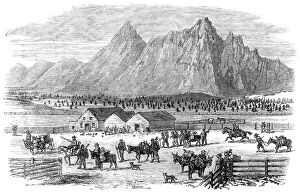
Sketches in British Columbia: scene at the fountain near Parsonville, Fraser River, 1864. Creator: UnknownSketches in British Columbia: scene at the fountain near Parsonville, Fraser River, 1864. 'The Fountain, eight miles from Parsonville, which is in quite another district
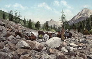
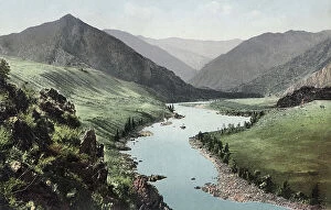
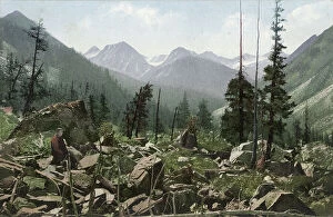
Path Along a Rock Field in the Valley of the Kuragan River, a Tributary of the Katun..., 1911-1913Path Along a Rock Field in the Valley of the Kuragan River, a Tributary of the Katun River; in the Vicinity of Belukha Mountain, 1911-1913
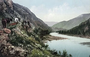
A Pack Road Along the Katun River near Its Confluence with the Argut River..., 1911-13A Pack Road Along the Katun River near Its Confluence with the Argut River. In the Vicinity of Iukhtener Mountain and Stream, 1911-1913
Cascade Waterfall near the Mouth of the Beltyr-Oek River, Left Tributary of the Katun..., 1911-1913Cascade Waterfall near the Mouth of the Beltyr-Oek River, Left Tributary of the Katun River, 1911-1913. From a collection of color postcards of the Altay, or Altai
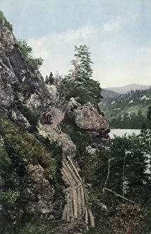
A Pack Road in the Katun River Valley near the Village of Tavda. Cliff "Skakun"..., 1911-1913A Pack Road in the Katun River Valley near the Village of Tavda. Cliff "Skakun." Log Boards for the Passage of Horses over the Precipice, 1911-1913
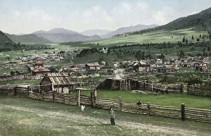
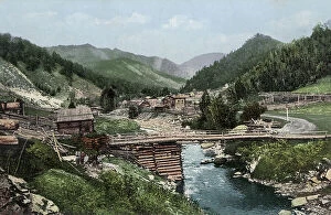
General View of the Village of Cherga, 1911-1913. Creator: Sergei Ivanovich BorisovGeneral View of the Village of Cherga, 1911-1913. From a collection of color postcards of the Altay, or Altai, Mountains region of southern Siberia early in the 20th century
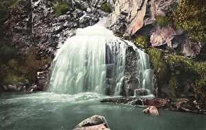
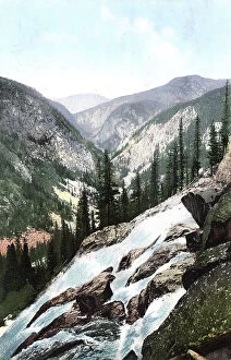
Kamyshlinsky Waterfall, located at the Confluence of the Kamyshla River...., 1911-1913Kamyshlinsky Waterfall, located at the Confluence of the Kamyshla River with the Katun River, 1911-1913. From a collection of color postcards of the Altay, or Altai
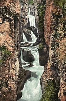
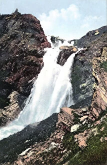
Rossypnaya Waterfall near the Source of the Katun River, ...Belukha Mountain, 1911-1913Rossypnaya Waterfall near the Source of the Katun River, the Vicinity of Belukha Mountain, 1911-1913. From a collection of color postcards of the Altay, or Altai
Manzherok Rapid on the Katun River, 1911-1913. Creator: Sergei Ivanovich BorisovManzherok Rapid on the Katun River, 1911-1913. From a collection of color postcards of the Altay, or Altai, Mountains region of southern Siberia early in the 20th century
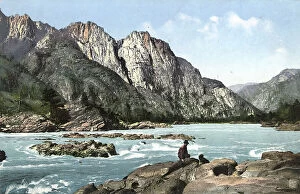
Rapid on the Katun River Above the Village of Chemal, 1911-1913. Creator: Sergei Ivanovich BorisovRapid on the Katun River Above the Village of Chemal, 1911-1913. From a collection of color postcards of the Altay, or Altai, Mountains region of southern Siberia early in the 20th century
Valley of the Katun River near the Village of Chemal, Teldekpen Rapid (Edigan Rapid), 1911-1913. From a collection of color postcards of the Altay, or Altai
Valley of the Belaya-Berel River, a Tributary of the Bukhtarma River in the Vicinity of..., 1911-13Valley of the Belaya-Berel, a Tributary of the Bukhtarma River in the Vicinity of Belukha Mountain, 1911-1913. From a collection of color postcards of the Altay, or Altai
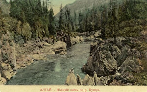
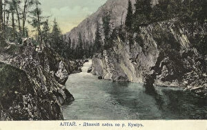
Valley of the Kumir River, a Tributary of the Charysh River; cliffs by the name..., 1911-1913Valley of the Kumir River, a Tributary of the Charysh River; cliffs by the name "Maiden Reach"., 1911-1913. From a collection of color postcards of the Altay, or Altai
Valley of the Kumir River, a Tributary of the Charysh River; cliffs by the mame..., 1911-1913Valley of the Kumir River, a Tributary of the Charysh River; cliffs by the mame "Maiden Reach", 1911-1913. From a collection of color postcards of the Altay, or Altai
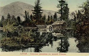
Water Mill in the Valley of the Uymon River, a Tributary of the Katun River, 1911-1913. From a collection of color postcards of the Altay, or Altai
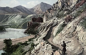
Chuyskiy Tract, on the Slopes of Kyngrar Cliff above the Confluence of the Yaloman... 1911-1913Chuyskiy Tract, on the Slopes of Kyngrar Cliff above the Confluence of the Yaloman River into the Katun River, 1911-1913. From a collection of color postcards of the Altay, or Altai
The Village of Elekmonar, Valley of the Middle Reaches of the Katun River, 1911-1913. Creator: Sergei Ivanovich BorisovThe Village of Elekmonar, Valley of the Middle Reaches of the Katun River, 1911-1913. From a collection of color postcards of the Altay, or Altai
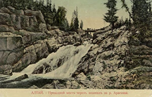
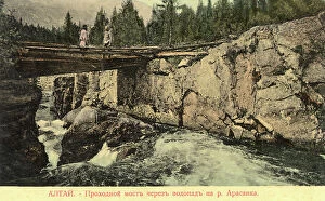
Bridge Across a Waterfall on the Arasan River, 1911-1913. Creator: Sergei Ivanovich BorisovBridge Across a Waterfall on the Arasan River, 1911-1913. From a collection of color postcards of the Altay, or Altai, Mountains region of southern Siberia early in the 20th century
Yurts of Kazakhs in the Valley of the Middle Reaches of the Katun River.; the Area..., 1911-1913Yurts of Kazakhs in the Valley of the Middle Reaches of the Katun River.; the Area of Airdash Between the Villages of Uznezia and Cheposh, 1911-1913
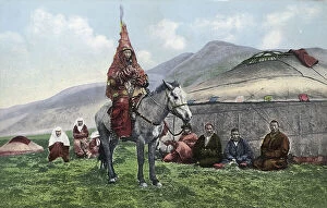
Kazakh Woman in Wedding Clothes on a Horse, 1911-1913. Creator: Sergei Ivanovich BorisovKazakh Woman in Wedding Clothes on a Horse, 1911-1913. From a collection of color postcards of the Altay, or Altai, Mountains region of southern Siberia early in the 20th century
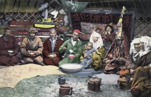
Inside a Kazakh Yurt, 1911-1913. Creator: Sergei Ivanovich BorisovInside a Kazakh Yurt, 1911-1913. From a collection of color postcards of the Altay, or Altai, Mountains region of southern Siberia early in the 20th century
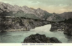
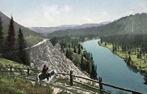
Valley of the Katun River near the Confluence of the Togus-Kan River, 1911-1913. Creator: Sergei Ivanovich BorisovValley of the Katun River near the Confluence of the Togus-Kan River, 1911-1913. From a collection of color postcards of the Altay, or Altai
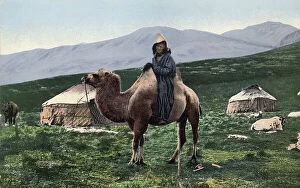
Kazakh on a Camel with Yurts in the Background, Valley of the Arakan River, a Tributary..., 1911-13Kazakh on a Camel with Yurts in the Background, Valley of the Arakan River, a Tributary of the Chernaia Berel River, 1911-1913
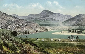
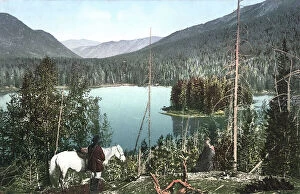
A Lake in the Valley of the Arasan River, a Tributary of the Belaia Berel River that..., 1911-13A Lake in the Valley of the Arasan River, a Tributary of the Belaia Berel River that Flows into the Bukhtarma River. In the Vicinity of Belukha Mountain., 1911-1913
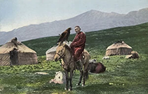
Kazakh with a Golden Eagle, on a Horse with Yurts in the Background, Valley of the Arakan...,1911-13 CreatorKazakh with a Golden Eagle, on a Horse with Yurts in the Background, Valley of the Arakan River, a Tributary of the Chernaia Berel River, 1911-1913
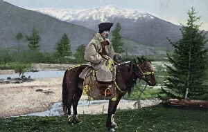
Altai Man in National Costume (Hat: Kuaraan Boruk, Sheepskin Coat: Ton, with a..., 1911-1913)Altai Man in National Costume (Hat: Kuaraan Boruk, Sheepskin Coat: Ton, with a Stepped Cutout) on a Horse, 1911-1913. From a collection of color postcards of the Altay, or Altai
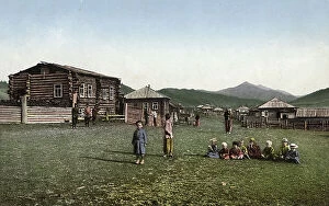
Street in the Village of Chyorny Anuy; Russian Children, 1911-1913. Creator: Sergei Ivanovich BorisovStreet in the Village of Chyorny Anuy; Russian Children, 1911-1913. From a collection of color postcards of the Altay, or Altai, Mountains region of southern Siberia early in the 20th century
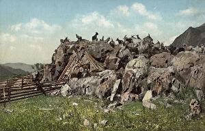
Valley of the Kuragan River, Right Tributary of the Katun River, in the Vicinity of..., 1911-1913Valley of the Kuragan River, Right Tributary of the Katun River, in the Vicinity of Belukha Mountain, 1911-1913. From a collection of color postcards of the Altay, or Altai
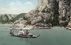
Crossing the Katun River on a Dugout Canoe near Dzhir-Bom, Above the Mouth of the Chui..., 1911-13Crossing the Katun River on a Dugout Canoe near Dzhir-Bom, Above the Mouth of the Chui River, 1911-1913. From a collection of color postcards of the Altay, or Altai
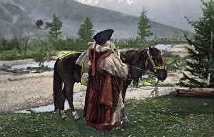
Altai Woman in National Costume (Hat: Kuaraan Boruk, Sheepskin Coat: Ton, Sleeveless..., 1911-1913)Altai Woman in National Costume (Hat: Kuaraan Boruk, Sheepskin Coat: Ton, Sleeveless Garment: Chegedek; Clothing of a Married Woman) with a Horse, 1911-1913
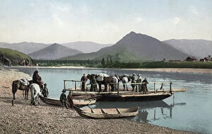
Ferry on the Katun River near the Village of Nizhny Uymon, 1911-1913. Creator: Sergei Ivanovich BorisovFerry on the Katun River near the Village of Nizhny Uymon, 1911-1913. From a collection of color postcards of the Altay, or Altai, Mountains region of southern Siberia early in the 20th century
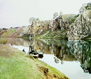
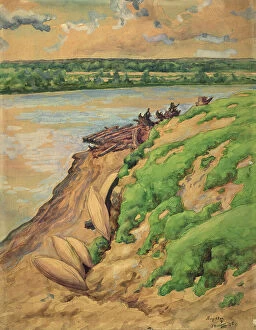
Upper Georgievskii Rock and a general view of the settlement of Utka, Chusovaya River, 1912. Several people with a small fishing boat.
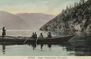
Boat on Lake Teletskoye, 1911-1913. Creator: Sergei Ivanovich BorisovBoat on Lake Teletskoye, 1911-1913. From a collection of color postcards of the Altay, or Altai, Mountains region of southern Siberia early in the 20th century
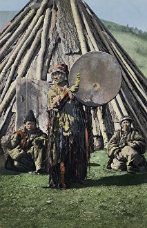
Altai Shaman with Tambourine in Front of a Traditional Dwelling (Chaadyr), 1911-1913. Creator: Sergei Ivanovich BorisovAltai Shaman with Tambourine in Front of a Traditional Dwelling (Chaadyr), 1911-1913. From a collection of color postcards of the Altay, or Altai
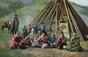
Group of Altai Beside a Dwelling (Chaadyr), Katun River Valley, 1911-1913. Creator: Sergei Ivanovich BorisovGroup of Altai Beside a Dwelling (Chaadyr), Katun River Valley, 1911-1913. From a collection of color postcards of the Altay, or Altai, Mountains region of southern Siberia early in the 20th century
Altai Dwelling (Chaadyr), Katun River Valley, 1911-1913. Creator: Sergei Ivanovich BorisovAltai Dwelling (Chaadyr), Katun River Valley, 1911-1913. From a collection of color postcards of the Altay, or Altai, Mountains region of southern Siberia early in the 20th century
Blue Cliff, Koksa River Valley, Uimon Tract, 1911-1913. Creator: Sergei Ivanovich BorisovBlue Cliff, Koksa River Valley, Uimon Tract, 1911-1913. From a collection of color postcards of the Altay, or Altai, Mountains region of southern Siberia early in the 20th century
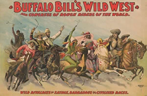
Buffalo Bill's Wild West and Congress of Rough Riders of the World [] : Wild rivalries of..., c1898Buffalo Bill's Wild West and Congress of Rough Riders of the World [] : Wild rivalries of savage, barbarous and civilized races, c1898
Yurt Kubalakh, 1927. Creator: Nikolaj Dmitrievic TravinYurt Kubalakh, 1927. From a collection of travel sketches created in the Yakut Autonomous Soviet Socialist Republic during the 1920s-1930s
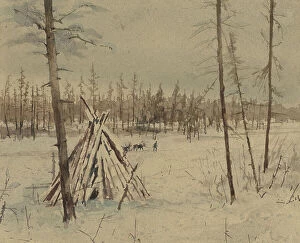
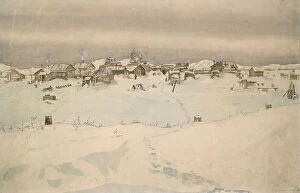
Kyusyur: Winter Landscape, 1929. Creator: Nikolaj Dmitrievic TravinKyusyur: Winter Landscape, 1929. From a collection of travel sketches created in the Yakut Autonomous Soviet Socialist Republic during the 1920s-1930s
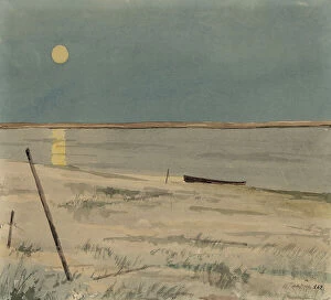
Night Landscape, 1928. Creator: Nikolaj Dmitrievic TravinNight Landscape, 1928. From a collection of travel sketches created in the Yakut Autonomous Soviet Socialist Republic during the 1920s-1930s
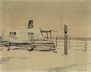
Yurt on the Duolgolakh River, unknown date. Creator: Nikolaj Dmitrievic TravinYurt on the Duolgolakh River, unknown date. From a collection of travel sketches created in the Yakut Autonomous Soviet Socialist Republic during the 1920s-1930s
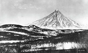
Klyuchevskoy volcano, 1922-1923. Creator: Rene MalaiseKlyuchevskoy volcano, 1922-1923. From an album of 296 works which offer a glimpse of life in the Russian Far Northeast in the first third of the twentieth century
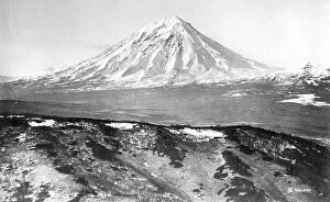
Koryaksky volcano, 1922-1923. Creator: Rene MalaiseKoryaksky volcano, 1922-1923. From an album of 296 works which offer a glimpse of life in the Russian Far Northeast in the first third of the twentieth century
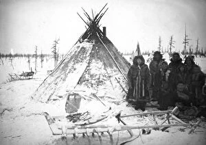
A group of Dolgans of the Yenisei province at the tent, 1925. Creator: UnknownA group of Dolgans of the Yenisei province at the tent, 1925. From a collection which includes more than two hundred photographs taken during scientific expeditions into the most remote wilderness
Laryak - Bank of the Vakh River, 1928. Creator: Dmitrii Innokent'evich KaratanovLaryak - Bank of the Vakh River, 1928. V. I. Surikov Museum of Art in Krasnoiarsk