mail_outline sales@mediastorehouse.com
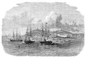
Embarkation at Cape Coast Castle of the troops recalled from the Ashantee War, 1864. Creator: UnknownEmbarkation at Cape Coast Castle of the troops recalled from the Ashantee War, 1864. Engraving from a sketch by Dr. Eames of H.M.S
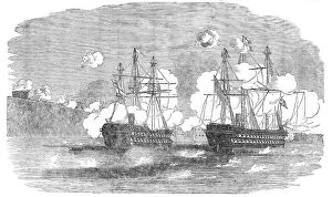
The Attack on the Peiho Forts by the English and French Fleets, 1858. Creator: Harvey Orrin SmithThe Attack on the Peiho Forts by the English and French Fleets, 1858. Fort, 8 Guns; Nimrod; Fort, 10 Guns; Avalanche (French)
The Attack on the Peiho Forts by the English and French Fleets, 1858. Creator: Harvey Orrin SmithThe Attack on the Peiho Forts by the English and French Fleets, 1858. Dragonne (French); Fort, 15 Guns; Slaney; Firm; Opossum; Severn; Staunch; Fusee (French); Cormorant; Bustard; Fort
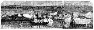
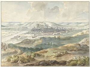
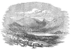
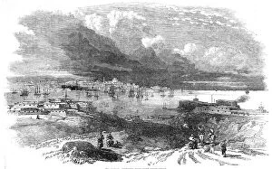
Tien-Tsin, on the banks of the Peiho River, 1860. Creator: UnknownTien-Tsin, on the banks of the Peiho River, 1860. The British in China. Small vessels only can approach the mouth of the Peiho River
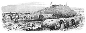
The War in China - interior of the North Fort Peiho - from a sketch by our special artist, 1860. Creator: UnknownThe War in China - interior of the North Fort Peiho - from a sketch by our special artist, 1860. British forces in the Far East
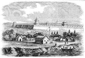
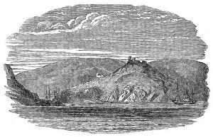
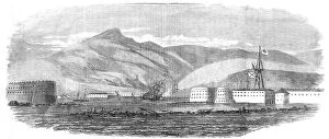
The War in China - the forts at the mouth of the Pehtang River, 1860. Creator: UnknownThe War in China - the forts at the mouth of the Pehtang River, 1860. British forces in the far east. The plan of operations decided upon was to land at the Pehtang River
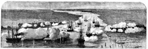
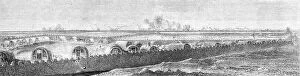
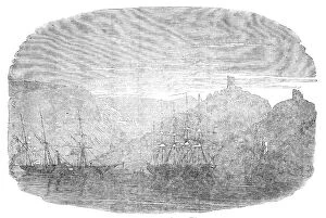
The attack on the Peiho Forts on the 21st of August, 1860... 1860. Creator: UnknownThe attack on the Peiho Forts on the 21st of August, 1860 - sketched by our special artist from the head-quarters of the military train, Tung-Ku, 1860
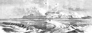
The storming and capture of the North Fort, Peiho, on the 21st August, 1860... Creator: UnknownThe storming and capture of the North Fort, Peiho, on the 21st August, 1860 - from a sketch by our special artist, 1860. British forces in China
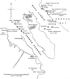
Plan of the Attack on the Forts and Batteries of Canton, Nov.12 and 13, 1856, (1857). Creator: UnknownPlan of the Attack on the Forts and Batteries of Canton, Nov.12 and 13, 1856, (1857). British naval officer:..we have had a job to take some forts called the Bocca Tigris
Map of the area between Bergen op Zoom and Steenbergen, 1630. Creator: Franciscus van SchootenMap of the area between Bergen op Zoom and Steenbergen, 1630. Tabula Bergarum ad Zomam Stenbergae'. Showing fortresses, trees, hills, harbours, areas susceptible to flooding
Sebastopol - North Side - sketched by J. A. Crowe, 1856. Creator: J. A. CroweSebastopol - North Side - sketched by J. A. Crowe, 1856. Crimean War: The position of the Russians on the north side of the harbour of Sebastopol...has remained without any alteration for the last
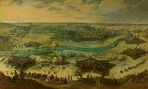
Map of Antwerp during the siege by the French, 1832, (1832-1833). Creators: Anon, Johannes Paulus HoutmanPlan showing Schelde and Antwerp with the location of the forts in Dutch hands, during the siege of the Citadel by the French, 1832, (1832-1833). Dutch gunboats on the Scheldt
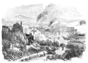
Canton and Part of the Suburbs, sketched during the Conflagration in the City, 1857. Creator: UnknownCanton and Part of the Suburbs, sketched during the Conflagration in the City, 1857. This Sketch is of interest as it was taken during the only fire of importance which we have succeeded as yet in
View of Namur from the East during the Siege of 1695, (1695). Creator: Dirk MaesView of Namur from the East during the Siege of 1695, (1695)
The Siege of Jülich, 1621-22, c.1635. Creator: Sebastian VrancxThe Siege of Julich, 1621-22, c.1635. Scene from the Eighty Years War. Attributed to Sebastiaen Vrancx
Reconnoitring at Cronstadt, 1854. Creator: UnknownReconnoitring at Cronstadt, 1854. Crimean War. Fort Peter I.; Fort Alexander; Fort Menschikoff; "Bulldog"; "Phlegethon"
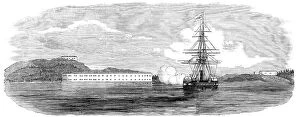
Bombardment of Bomarsund, 1854. Creator: UnknownBombardment of Bomarsund, 1854. 2nd Round Fort - Long Fort, 80 Guns - "Odin" - 3rd Round Fort'. British warships during the Aland War - British-French naval force against military
Bombardment of Bomarsund, 1854. Creator: UnknownBombardment of Bomarsund, 1854. Riflemen - Masked Battery - "Hecla" - 1st Round Fort - "Valorous" - Village of Bomarsund'. British warships during the Aland War
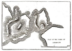
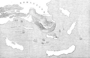
Plan of the Forts of Bomarsund, 1854. Creator: UnknownPlan of the Forts of Bomarsund, 1854. From "Cassell's Illustrated Family Paper; London Weekly 31 Dec 1853 to 30 Dec 1854"
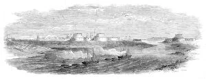
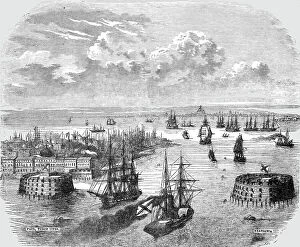
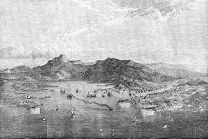
Cronstadt, 1854. Creator: UnknownCronstadt, 1854. From "Cassells Illustrated Family Paper; London Weekly 31/12/1853 - 30/12/1854"
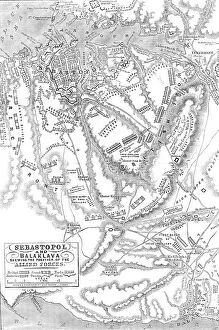
Sebastopol and Balaclava shewing the position of the Allied Forces, 1854. Creator: John DowerSebastopol and Balaclava shewing the position of the Allied Forces, 1854. Crimean War. The severe and costly battles of Balaclava and Inkerman
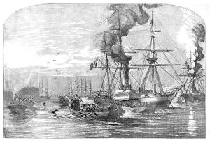
Naval Attack on the Russian Fort of Petropaulovski, 1854. Creator: UnknownNaval Attack on the Russian Fort of Petropaulovski, [Kamchatka], 1854. Crimean War. French and English warships: L'Obligator; Virago; Eurydice
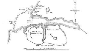
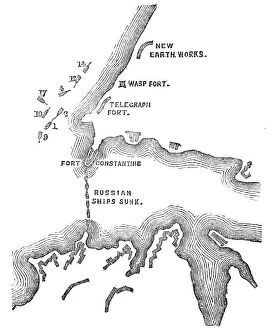
The Coast North of Sebastopol, and New Earth Batteries, 1854. Creator: UnknownThe Coast North of Sebastopol, and New Earth Batteries, 1854. Crimean War. Map of the strategic Black Sea port, ...sketched on board H.M.S
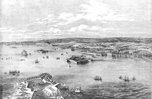
New Russian Works, 1854. Creator: UnknownNew Russian Works, 1854. Crimean War. Map showing the besieged Black Sea port of Sebastopol. English, French and Turkish ships are ranged across the entrance to the harbour
Entrance to Balaclava Harbour, 1854. Creator: UnknownEntrance to Balaclava Harbour, 1854. Crimean War. The town of Balaclava is situated close to the harbour, along the foot of the mountain, but it is not provided with good water
Balaclava - view inside the port, 1854. Creator: UnknownBalaclava - view inside the port, 1854. Crimean War. View of the'...inside of the port, which is only accessible through a very narrow circuitous channel, in the form of the letter S
Balaclava Harbour, 1854. Creator: UnknownBalaclava Harbour, 1854. Crimean War....Balaclava has been completely changed into a Greek town...[It] is situated close to the harbour, along the foot of the mountain
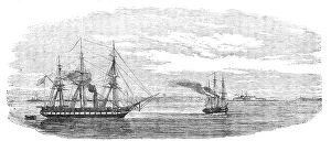
The "Agamemnon" and "Sanspareil" attacking Sebastopol, 1854. Creator: UnknownThe "Agamemnon" and "Sanspareil" attacking Sebastopol, 1854. Crimean War: Royal Navy ships....the Agamemnon...opened fire from her large pivot gun on the "Wasp" Fort
Sebastopol, sketched from Fort Constantine, 1854. Creator: UnknownSebastopol, sketched from Fort Constantine, 1854. Crimean War: strategic port on the Black Sea under siege. [British commander] Lord Raglan, it is said, received a few days ago
The Sunken Ships at the Mouth of the Harbour of Sebastopol, sketched by Lieut. Montagu... 1854. Creator: UnknownThe Sunken Ships at the Mouth of the Harbour of Sebastopol, sketched by Lieut. Montagu O'Reilly, H.M.S. Retribution, 1854. Crimean War
British Outposts, near Sebastopol, 1854. Creator: UnknownBritish Outposts, near Sebastopol, 1854. Crimean War: panorama showing Cossacks; Fort; English Steamer; Russian Soldiers Camp Cooking Houses
Sebastopol - from an original drawing, 1854. Creator: Edmund EvansSebastopol - from an original drawing, 1854. Crimean War. Warships on the Black Sea near the port of Sebastopol. The Siege of Sevastopol was the subject of Crimean soldier Leo Tolstoy's
Fortifications of Bomarsund, 1854. Creator: UnknownFortifications of Bomarsund, 1854. Crimean War. Map of Russian forts on the Baltic Sea coast in Findland. Also shown are positions of the English and French armies
Steam-ships of the Allied Fleet searching for Infernal Machines off Cronstadt... 1854. Creator: UnknownSteam-ships of the Allied Fleet searching for Infernal Machines off Cronstadt - from a sketch by W.O. Brierly, 1854. Crimean War
Cronstadt, from the Narrow Part of the Channel nearest St. Petersburg, drawn by E.T. Dolby, 1854. Creator: UnknownCronstadt, from the Narrow Part of the Channel nearest St. Petersburg, drawn by E.T. Dolby, 1854. Defences in the Russian port city during the Crimean War
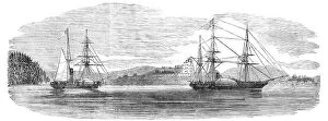
Steam-ships reconnoitring at Sveaborg, in the Gulf of Finland, 1854. Creator: UnknownSteam-ships reconnoitring at Sveaborg, in the Gulf of Finland, 1854. Crimean War: Royal Navy ships off Russian-held Sveaborg [modern Suomenlinna]
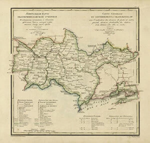
General Map of Ekaterinoslav Province: Showing Postal and Major Roads, Stations and the... 1821General Map of Ekaterinoslav Province: Showing Postal and Major Roads, Stations and the Distance in Versts between Them, 1821
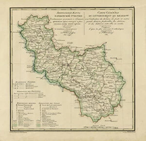
General Map of Kharkiv Province: Showing Postal and Major Roads, Stations and the... 1821General Map of Kharkiv Province: Showing Postal and Major Roads, Stations and the Distance in Versts between Them, 1821. This 1821 map of Kharkiv Provinceis from a larger work
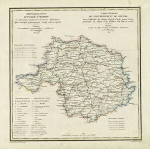
General Map of Kursk Province: Showing Postal and Major Roads, Stations and the... 1822General Map of Kursk Province: Showing Postal and Major Roads, Stations and the Distance in Versts between Them, 1822. This 1822 map of Kursk Provinceis from a larger work
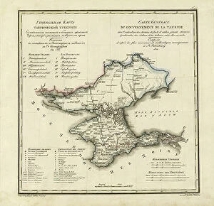
General Map of Taurida Province: Showing Postal and Major Roads, Stations and.. 1822General Map of Taurida Province: Showing Postal and Major Roads, Stations and the Distance in Versts between Them, 1822. This 1822 map ofTaurida Provinceis from a larger work
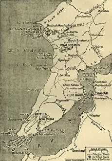
Map of the Gallipoli Peninsula, 1919. Creator: George Philip & Son LtdMap of the Gallipoli Peninsula, 1919. The Gallipoli peninsula in western Turkey saw heavy fighting during the First World War, 1914-1919, with many casualties on both sides
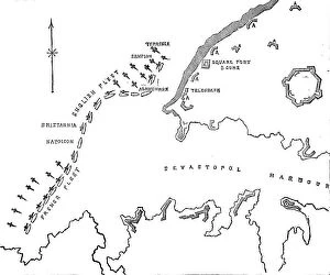
Plan of the Attack at 5.30pm, when these were almost exclusively the Ships engaged with the... 1854 Creator: UnknownPlan of the Attack at 5.30pm, when these were almost exclusively the Ships engaged with the Forts, 1854. Crimean War. Map showing the besieged Black Sea port of Sebastopol
Assault on Two Fortresses, c. 1614. Creator: Jacques CallotAssault on Two Fortresses, c. 1614
Assault on the Outer Forts of Bone, c. 1614. Creator: Jacques CallotAssault on the Outer Forts of Bone, c. 1614
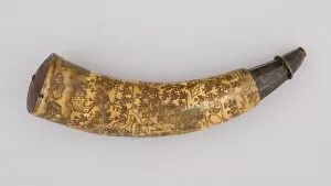
Powder Horn, Colonial American, dated 1759. Creator: UnknownPowder Horn, Colonial American, dated 1759
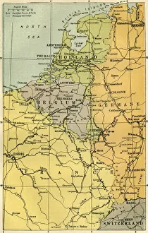
Map of the Belgian Frontier with Forts, 1919. Creator: UnknownMap of the Belgian Frontier with Forts, 1919. Map showing Belgium, Holland and parts of Germany and France during the First World War, 1914-1919. Fortified towns and principal railways are indicated
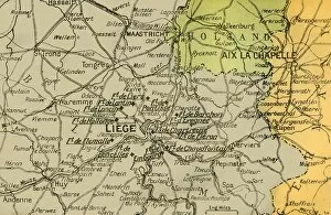
Map Showing the Forts of Liege, 1919. Creator: London Geographical InstituteMap Showing the Forts of Liege, 1919. Forts in Belgium during the First World War, 1914-1919. From " The History of the Great European War: its causes and effects", Vol. II, by W
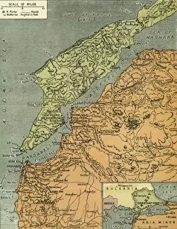
The Dardanelles with its Forts, 1919. Creator: London Geographical InstituteThe Dardanelles with its Forts, 1919. Map of the Turkish coast showing the Gallipoli peninsula which saw heavy fighting during the First World War, 1914-1919, with many casualties on both sides