mail_outline sales@mediastorehouse.com
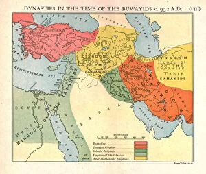
Dynasties in the time of the Buwayids, circa 932 A. D. c1915. Creator: Emery Walker LtdDynasties in the time of the Buwayids, circa 932 A.D. c1915. Map of civilisations in the Middle East during the 10th century: Byzantine, Buwayid Kingdom, Abbasid Caliphate, Kingdom of the Ikhshids
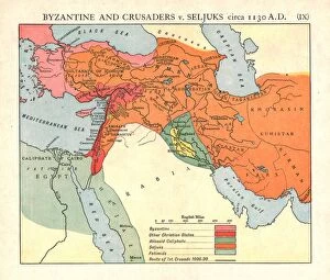
Byzantine and Crusaders v. Seljuks, circa 1130 A. D. c1915. Creator: Emery Walker LtdByzantine and Crusaders v. Seljuks, circa 1130 A.D. c1915. Map of civilisations in the Middle East during the 12th century: Byzantine, other Christian states, Abbasid Caliphate, Seljuks, Fatimids
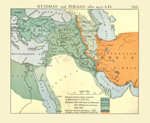
Ottoman and Persian, after 1450 A. D. c1915. Creator: Emery Walker LtdOttoman and Persian, after 1450 A.D. c1915. Map of empires in the Middle East during the 15th-17th centuries: Ottoman Empire at the accession of Mohammed II, 1451 AD, Additions 1481-1683
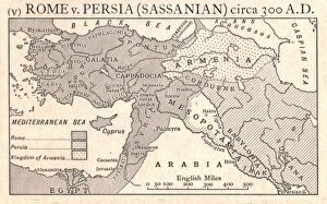
Rome v. Persia (Sassanian), circa 300 A. D. c1915. Creator: Emery Walker LtdRome v. Persia (Sassanian), circa 300 A.D. c1915. Map of the eastern Mediterranean and Near East, showing the ancient empires of Rome, Persia, and Armenia
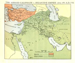
The Abbasid Caliphate v. Byzantine Empire, circa 786 A. D. c1915. Creator: Emery Walker LtdThe Abbasid Caliphate v. Byzantine Empire, circa 786 A.D. c1915. Map of civilisations in the Middle East during the 8th century, and also showing the eastern Mediterranean, Red Sea, Caspian Sea
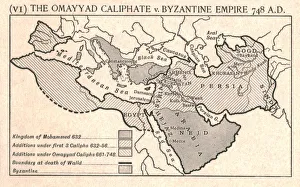
The Omayyad Caliphate v. Byzantine Empire, circa 748 A. D. c1915. Creator: Emery Walker LtdThe Omayyad Caliphate v. Byzantine Empire, circa 748 A.D. c1915. Map of the Mediterranean and Near East, showing the Kingdom of Mohammed, Additions under the Caliphs
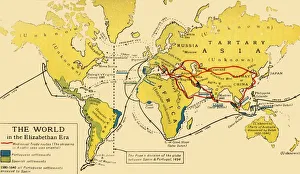
The World in the Elizabethan Era, 1926. Creators: Unknown, Emery Walker LtdThe World in the Elizabethan Era, 1926. Map of the world during the reign of Queen Elizabeth I (1558-1603). The key shows: Mediaeval Trade routes, (the shipping in Asiatic seas was oriental)
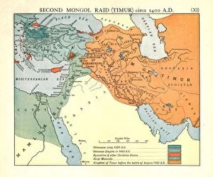
Second Mongol Raid (Timur), circa 1450 A. D. c1915. Creator: Emery Walker LtdSecond Mongol Raid (Timur), circa 1450 A.D. c1915. Map of civilisations in the Middle East during the 14th and 15th centuries: Ottomans c1350 AD, Ottoman Empire in 1400 AD
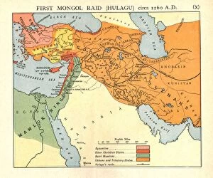
First Mongol Raid (Hulagu), circa 1400 A. D. c1915. Creator: Emery Walker LtdFirst Mongol Raid (Hulagu), circa 1400 A.D. c1915. Map of civilisations in the Middle East during the early 15th century: Byzantine, other Christian states, Bahri Mamluks
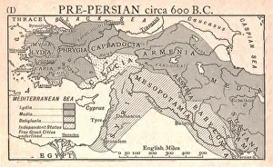
Pre-Persian, circa 600 B. C. c1915. Creator: Emery Walker LtdPre-Persian, circa 600 B.C. c1915. Map of the eastern Mediterranean and near East, showing the ancient civilisations of empires of Lydia, Media, Babylonia, Independent States, and free Greek cities
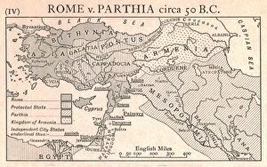
Rome v. Parthia, circa 50 B. C. c1915. Creator: Emery Walker LtdRome v. Parthia, circa 50 B.C. c1915. Map of the eastern Mediterranean and Near East, showing the ancient empires of Rome, Parthia, Armenia, and Protected and Independent States
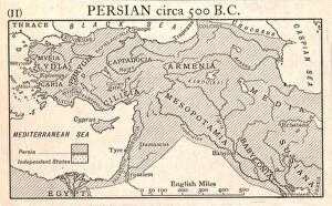
Persian, circa 500 B. C. c1915. Creator: Emery Walker LtdPersian, circa 500 B.C. c1915. Map of the eastern Mediterranean and Near East, showing the ancient Persian empire and Independent States
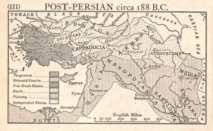
Post-Persian, circa 188 B. C. c1915. Creator: Emery Walker LtdPost-Persian, circa 188 B.C. c1915. Map of the eastern Mediterranean and Near East, showing the ancient empires of Pergamum, Seleucid, Free Greek States, Gauls, Ptolemy, and Independent States
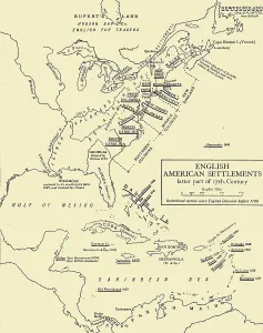
English American Settlements - latter part of 17th Century, 1926. Creators: UnknownEnglish American Settlements - latter part of 17th Century, 1926. Map of the eastern coast of North America, the Caribbean and the north coast of South America, showing areas settled by Europeans
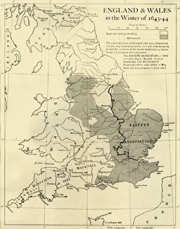
England & Wales in the Winter of 1643-44, 1926. Creators: Unknown, Emery Walker LtdEngland & Wales in the Winter of 1643-44, 1926. Map showing England and Wales during the Civil War period. The key shows districts held by the king (Charles I), and by parliament
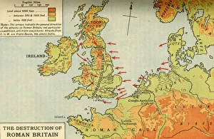
The Destruction of Roman Britain, 1926. Creators: Unknown, Emery Walker LtdThe Destruction of Roman Britain, 1926. Map of Britain showing invasions towards the end of the Roman period (43 to 410 AD)
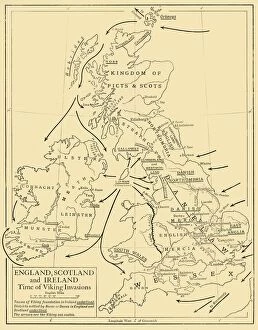
England, Scotland and Ireland - Time of Viking Invasions, 1926. Creators: UnknownEngland, Scotland and Ireland - Time of Viking Invasions, 1926. Map of Britain during the 9th-11th century. Towns of Viking foundation in Ireland underlined
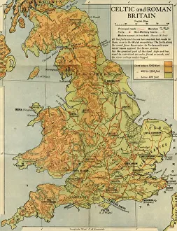
Celtic and Roman Britain, 1926. Creator: Emery Walker LtdCeltic and Roman Britain, 1926. Map of Britain during the Roman (43 to 410 AD) and Celtic periods. All the forts and towns here marked had roads to them, even in the Welsh mountains