mail_outline sales@mediastorehouse.com
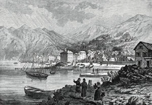
The War in the Herzegovina: Risano, Dalmatia, 1876. Creator: UnknownThe War in the Herzegovina: Risano, Dalmatia, 1876. Austrian seaport town...from which the insurgents have...obtained supplies to carry on this struggle...The continuance of this fierce struggle of
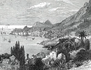
The War in the Herzegovina: Ragusa, Dalmatia, 1876. Creator: UnknownThe War in the Herzegovina: Ragusa, Dalmatia, 1876. Austrian seaport town...from which the insurgents have...obtained supplies to carry on this struggle...The continuance of this fierce struggle of
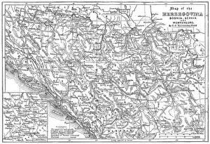
Map of the Herzegovina, Bosnia, Servia and Montenegro, 1876. Creator: UnknownMap of the Herzegovina, Bosnia, Servia and Montenegro, 1876. Map showing the theatre of war of the Herzegovina Uprising. Reference: The names are spelt agreably to English pronunciation
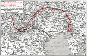
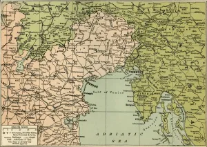
Le Champ de Bataille de L'Italie; mouvement des operations Italiennes jusqu'a la fin... 1917. Creator: UnknownLe Champ de Bataille de L'Italie; mouvement des operations Italiennes jusqu'a la fin de l'annee 1917, 1917. First World War
View of Trani located on the coast, 1778. Creator: Louis DucrosView of Trani located on the coast, 1778. Drawing from the album Voyage to Italy, Sicily and Malta
Ancona, in the Papal States, 1860. Creator: UnknownAncona, in the Papal States, 1860. Ancona is a fort on the Adriatic, and the chief naval station of the Papal States, occupying a fine situation on the slopes which rise from the Adriatic
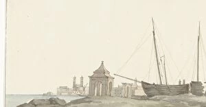
Classic column in the port of Brindisi, 1778. Creator: Louis DucrosClassic column in the port of Brindisi, 1778. Drawing from the album Voyage to Italy, Sicily and Malta
Port of Barletta with ships, 1778. Creator: Louis DucrosPort of Barletta with ships, 1778. Drawing from the album Voyage to Italy, Sicily and Malta
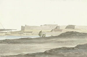
View of the castle in the port of Barletta, 1778. Creator: Louis DucrosView of the castle in the port of Barletta, 1778. Drawing from the album Voyage to Italy, Sicily and Malta
View of the city of Molfetta on the coast, 1778. Creator: Louis DucrosView of the city of Molfetta on the coast, 1778. Drawing from the album Voyage to Italy, Sicily and Malta
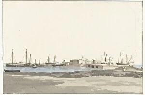
View of the roadstead with ships anchored at Bari, 1778. Creator: Louis DucrosView of the roadstead with ships anchored at Bari, 1778. Drawing from the album Voyage to Italy, Sicily and Malta
View on the coast of the Adriatic Sea with an observation tower on the other side of Monopoli, 1778. Drawing from the album Voyage to Italy, Sicily and Malta
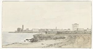
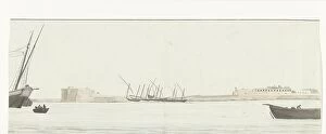
View of the port of Trani from the water, 1778. Creator: Louis DucrosView of the port of Trani from the water, 1778. Drawing from the album Voyage to Italy, Sicily and Malta
View of the port of Trani, 1778. Creator: Louis DucrosView of the port of Trani, 1778. Drawing from the album Voyage to Italy, Sicily and Malta
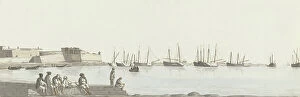
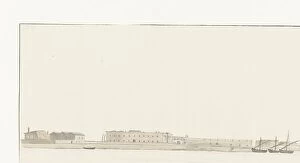
View of the port of Bari on the south side, 1778. Creator: Louis DucrosView of the port of Bari on the south side, 1778. Drawing from the album Voyage to Italy, Sicily and Malta
Arrival in Brindisi after crossing of the Adriatic Sea, 1778. Creator: Louis DucrosArrival in Brindisi after crossing of the Adriatic Sea, 1778. Drawing from the album Voyage to Italy, Sicily and Malta
Fisherman's houses on Lussin, 1913. Creator: Friedrich BeckFisherman's houses on Lussin, 1913
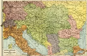
Austria-Hungary and Neighbouring Lands - Map, 1920. Creator: John Bartholomew & SonAustria-Hungary and Neighbouring Lands, c1914, (c1920). Map of the Austro-Hungarian Empire and surrounding countries at start of the First World War
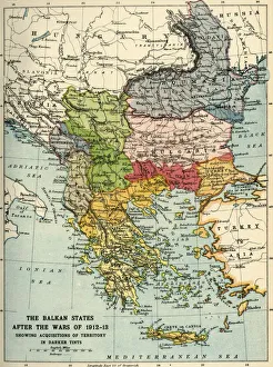
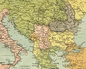
The Balkan States After the Wars of 1912-13, (c1920). Creator: John Bartholomew & SonThe Balkan States After the Wars of 1912-13, (c1920). Showing Acquisitions of Territory in Darker Tints. Map of the Balkans: Bosnia, Montenegro, Servia (Serbia), Albania, Roumania (Romania)
Second View of the Gulf of Venice, ca. 1770-1800. Creator: Francois Anne DavidSecond View of the Gulf of Venice, ca. 1770-1800
Allegory of the Foglia River with the city of Pesaros coat of arms, frontispiece for Il Pesarese, ca. 1639
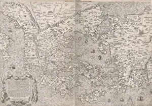
Speculum Romanae Magnificentiae: Map of Greece, mid-16th century. mid-16th centurySpeculum Romanae Magnificentiae: Map of Greece, mid-16th century
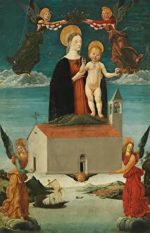
The Translation of the Holy House of Loreto, ca. 1510. Creator: Saturnino GattiThe Translation of the Holy House of Loreto, ca. 1510
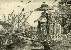
The Wedding of the Adriatic, (c991-1009), 1890. Creator: UnknownThe Wedding of the Adriatic, (c991-1009), 1890. Doge Pietro II Orseolo (961-1009) began a tradition of sailing into the Adriatic Sea and throwing a ring into the water, pledging I wed thee, O Sea
Map To Illustrate the Eastern Battle Fronts, 1919. Creator: George Philip & Son LtdMap To Illustrate the Eastern Battle Fronts, 1919. Map showing areas of eastern Europe and the Balkans which saw fighting during the First World War, 1914-1919, including Italy, Austria-Hungary
Map of the Italian Fighting Front, 1919. Creator: George Philip & Son LtdMap of the Italian Fighting Front, 1919. Map showing north-eastern Italy, the Trentino and part of southern Austria during the First World War, 1914-1919
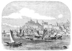
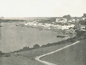
General view, Brindisi, Italy, 1895. Creator: UnknownGeneral view, Brindisi, Italy, 1895. Port on the Adriatic coast in southern Italy. From " Round the World in Pictures and Photographs
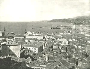
Town and harbour, Trieste, Italy, 1895. Creator: W &s LtdTown and harbour, Trieste, Italy, 1895. Seaport in northeastern Italy, between the Adriatic Sea and Slovenia. From " Round the World in Pictures and Photographs