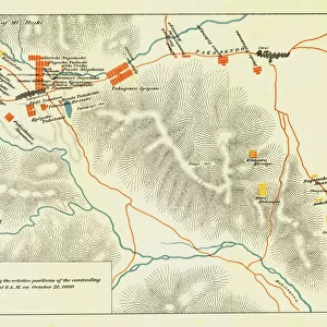
The Great Arras Battle Area, 1917. Creator: Unknown

![]()
Wall Art and Photo Gifts from Heritage Images
The Great Arras Battle Area, 1917. Creator: Unknown
The Great Arras Battle Area, 1917. From " The War Illustrated Album De Luxe - Volume VIII. Ending The First Three Years", edited by J. A. Hammerton. [The Amalgamated Press, Limited, London, 1917]
Media ID 19661363
© The Print Collector/Heritage Images
Amalgamated Press Amalgamated Press Limited Amalgamated Press Ltd Arras Arras Nord Pas De Calais France Battle Of Arras Campaign Cartography Hammerton Hammerton J A Hammerton Ja Hammerton Sir John Alexander J A Hammerton Ja Hammerton John Hammerton Map Making Military Campaign Military Strategy Nord Pas De Calais Sir John Alexander Sir John Alexander Hammerton Sir John Hammerton Strategic Strategy The Amalgamated Press War Illustrated
MADE IN THE UK
Safe Shipping with 30 Day Money Back Guarantee
FREE PERSONALISATION*
We are proud to offer a range of customisation features including Personalised Captions, Color Filters and Picture Zoom Tools
SECURE PAYMENTS
We happily accept a wide range of payment options so you can pay for the things you need in the way that is most convenient for you
* Options may vary by product and licensing agreement. Zoomed Pictures can be adjusted in the Basket.