
New England in 1660, (c1880)

New England in 1660, (c1880)


Photo Prints
Poster Prints
Cards
Jigsaw Puzzles
Fine Art Prints
Canvas Prints
Home Decor
Mounted Prints
Metal Prints


We accept all major credit cards

Wall Art and Photo Gifts from Heritage Images

New England in 1660, (c1880)

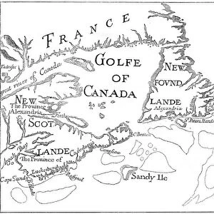
New England in 1660, (c1880). From Blaeus Theatre du Monde. In this curious map the north is at the bottom and the south at the top. A print from Cassells History of the United States, by Edmund Ollier, Volume I, Cassell Petter and Galpin, London, c1880

Media ID 14946159

© The Print Collector / Heritage-Images

Blaeu Cartography Colonisation Colony Deer Edmund Edmund Ollier Joan Joan Blaeu Johann Blaeu Johannes Blaeu Map Making New England Ollier


MADE IN THE UK
Safe Shipping with 30 Day Money Back Guarantee

FREE PERSONALISATION*
We are proud to offer a range of customisation features including Personalised Captions, Color Filters and Picture Zoom Tools

SECURE PAYMENTS
We happily accept a wide range of payment options so you can pay for the things you need in the way that is most convenient for you

* Options may vary by product and licensing agreement. Zoomed Pictures can be adjusted in the Basket.


redeem
Beautiful Photo Prints and Gifts
image
Professionally Printed
inventory
Photo Prints are in stock
thumb_up
Professional quality finish
diamond
Made with high-grade materials
inventory_2
Carefully packed to aid safe arrival


Related Images


Map of County Kerry, Ireland, 1924-1926
The Winner, 1913. Artist: William Newenham Montague Orpen
Old map of Acadia, 17th century (c1880)
A map of the Cape of Good Hope, South Africa, 1719 (1931)
Sir Walter Scott, 1st Baronet, Scottish historical novelist and poet, 1870. Artist: John Watson-Gordon
Map of Europe, a page from Liber Floridus, 12th century
Atlas, 1615. Artist: Leonard Gaultier
Map of the Paris Universal Exposition, 1900
Map of Alexandria, Egypt, 17th century

+

Shipping

+

Choices

+

Guaranteed