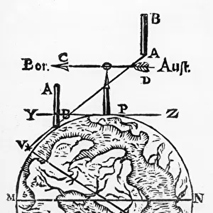
Map of the World, According to Ptolemy, 1923. Creator: Agathodaemon of Alexandria

![]()
Wall Art and Photo Gifts from Heritage Images
Map of the World, According to Ptolemy, 1923. Creator: Agathodaemon of Alexandria
Map of the World, According to Ptolemy, 1923. From " Australia, New Zealand and Oceania in Pictures", by H. Clive Barnard, M.A. Blitt. [A. & C. Black, Limited, London, 1923]
Media ID 18322492
© The Print Collector/Heritage Images
2nd Century Alexandria Barnard Cartography Claudius Claudius Of Ptolemaeus Claudius Ptolemy H Clive H Clive Barnard Map Making Ptolemaic Ptolemy World Map
MADE IN THE UK
Safe Shipping with 30 Day Money Back Guarantee
FREE PERSONALISATION*
We are proud to offer a range of customisation features including Personalised Captions, Color Filters and Picture Zoom Tools
SECURE PAYMENTS
We happily accept a wide range of payment options so you can pay for the things you need in the way that is most convenient for you
* Options may vary by product and licensing agreement. Zoomed Pictures can be adjusted in the Basket.