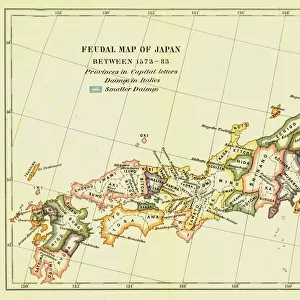
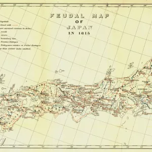
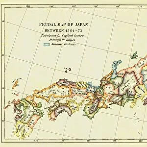
Map of Japan in Provinces in time of Iyeyasu, 1903. Creator: Unknown

![]()
Wall Art and Photo Gifts from Heritage Images
Map of Japan in Provinces in time of Iyeyasu, 1903. Creator: Unknown
Map of Japan in Provinces in time of Iyeyasu, 1903. Tokugawa Ieyasu (1543-1616) first shogun of the Tokugawa shogunate which ruled Japan from 1600-1868 and is known as the Edo period. Leyasu chose to distance Japan from European influence, although granting trading rights to the Dutch East India Company, in 1614 he signed the Christian Expulsion Edict which banned the practice of Christianity. From A History of Japan during the century of early foreign intercourse (1542-1651) by James Murdoch, M.A. and Isoh Yamagata. [Kobe, Japan, 1903]
Media ID 19667033
© The Print Collector/Heritage Images
Cartography Division Dutch East India Company Edo Bakufu Government Ieyasu Ieyasu Tokugawa Island Isoh Isoh Yamagata Iyeyasu James Murdoch Map Making Murdoch Murdoch James Nikko Tosho Gu Pacific Ocean Province Tokugawa Tokugawa Bakufu Tokugawa Ieyasu Tokugawa Shogunate Yamagata Yamagata Isoh
MADE IN THE UK
Safe Shipping with 30 Day Money Back Guarantee
FREE PERSONALISATION*
We are proud to offer a range of customisation features including Personalised Captions, Color Filters and Picture Zoom Tools
SECURE PAYMENTS
We happily accept a wide range of payment options so you can pay for the things you need in the way that is most convenient for you
* Options may vary by product and licensing agreement. Zoomed Pictures can be adjusted in the Basket.