Map illustrating the Battle of the Falkland Islands on 8 December 1914, (c1920). Creator: Unknown
. Creator: Unknown")
![]()
Wall Art and Photo Gifts from Heritage Images
Map illustrating the Battle of the Falkland Islands on 8 December 1914, (c1920). Creator: Unknown
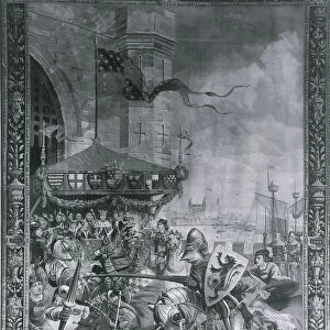
Map illustrating the Battle of the Falkland Islands on 8 December 1914, (c1920). Diagram showing movements during the Battle of the Falkland Islands, a naval engagement of the First World War, fought in the South Atlantic between the Royal Navy and the Kaiserliche Marine (Imperial German Navy). The German SMS Scharnhorst was lost with all hands. From " The Great World War - A History" Volume II, edited by Frank A Mumby. [The Gresham Publishing Company Ltd, London, c1920]
Media ID 19175245
© The Print Collector/Heritage Images
1st Baronet A History Atlantic Ocean Diagram Frank Arthur Frank Arthur Mumby Gneisenau Gresham Publishing Co Ltd Gresham Publishing Company Keystone Archives Mumby Mumby Frank Arthur Naval Battle Naval Ship Ocean Royal Navy Sea Battle Squadron The Great World War The Great World War A History Theatre Of War Warships
MADE IN THE UK
Safe Shipping with 30 Day Money Back Guarantee
FREE PERSONALISATION*
We are proud to offer a range of customisation features including Personalised Captions, Color Filters and Picture Zoom Tools
SECURE PAYMENTS
We happily accept a wide range of payment options so you can pay for the things you need in the way that is most convenient for you
* Options may vary by product and licensing agreement. Zoomed Pictures can be adjusted in the Basket.