Map of the Battle of Courcelles, 14 August 1870, (c1872). Creator: R. Walker
. Creator: R. Walker")
![]()
Wall Art and Photo Gifts from Heritage Images
Map of the Battle of Courcelles, 14 August 1870, (c1872). Creator: R. Walker
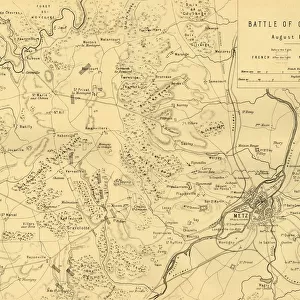
Map of the Battle of Courcelles, 14 August 1870, (c1872). Map: Drawn under the Superintendance of Captain Hozier, showing the enemy positions. The Battle of Borny-Colombey, (also known as the Battle of Colombey-Nouilly or the Battle of Courcelles), was fought near Metz (in France) between the French under Francois Bazaine, and the Prussians under Prince Frederick Charles. From " The Franco-Prussian War: its causes, incidents and consequences", Volume I, by Captain H M Hozier. [William Mackenzie, London, 1872]
Media ID 19778777
© The Print Collector/Heritage Images
1870 1871 Bamp W Franco Prussian War Front Line Frontline H M Hozier Henry Montague Henry Montague Hozier Hozier Lines Lorraine Mackenzie Metz Mosel Moselle Prussian Army R Walker River Mosel Robert Walker Sir Henry Montagu Hozier Walker William Mackenzie
MADE IN THE UK
Safe Shipping with 30 Day Money Back Guarantee
FREE PERSONALISATION*
We are proud to offer a range of customisation features including Personalised Captions, Color Filters and Picture Zoom Tools
SECURE PAYMENTS
We happily accept a wide range of payment options so you can pay for the things you need in the way that is most convenient for you
* Options may vary by product and licensing agreement. Zoomed Pictures can be adjusted in the Basket.
![The House with the Inscription [left], 1741. Creator: Canaletto](/sq/731/house-inscription-left-1741-creator-21234887.jpg.webp)