mail_outline sales@mediastorehouse.com
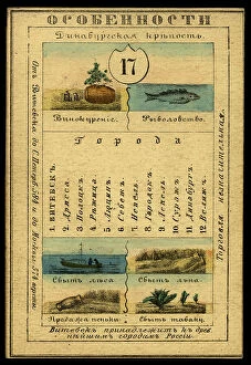
Vitebsk Province, 1856. Creator: UnknownVitebsk Province, 1856. This card is one of a souvenir set of 82 illustrated cards-one for each province of the Russian Empire as it existed in 1856
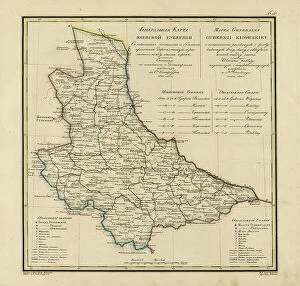
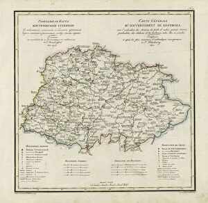
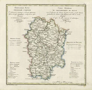
General Map of Kiev Province: Showing Postal and Major Roads, Stations and.. 1821General Map of Kiev Province: Showing Postal and Major Roads, Stations and the Distance in Versts between Them, 1821. This 1821 map of Kiev Province is from a larger work
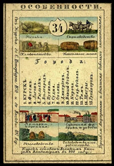
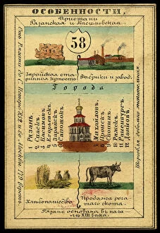
Kursk Province, 1856. Creator: UnknownKursk Province, 1856. This card is one of a souvenir set of 82 illustrated cards-one for each province of the Russian Empire as it existed in 1856
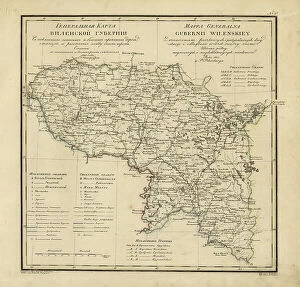
General Map of Vilnius Province: Showing Postal and Major Roads, Stations and the... 1820General Map of Vilnius Province: Showing Postal and Major Roads, Stations and the Distance in Versts between Them, 1820. This 1820 map of Vilnius Provinceis from a larger work
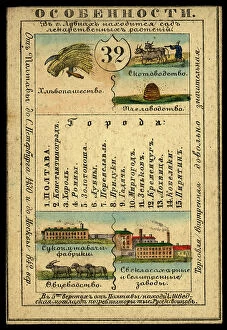
Poltava Province, 1856. Creator: UnknownPoltava Province, 1856. This card is one of a souvenir set of 82 illustrated cards-one for each province of the Russian Empire as it existed in 1856
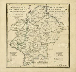
General Map of Grodno Province and the Belostok Region: Showing Postal and Major Roads... 1820General Map of Grodno Province and the Belostok Region: Showing Postal and Major Roads, Stations and the Distance in Versts between Them, 1820
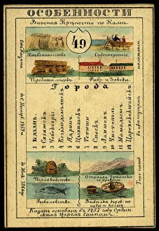
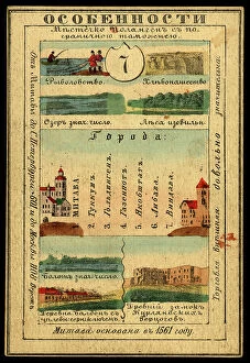
Kazan Province, 1856. Creator: UnknownKazan Province, 1856. This card is one of a souvenir set of 82 illustrated cards-one for each province of the Russian Empire as it existed in 1856
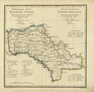
General Map of Podolsk Province: Showing Postal and Major Roads, Stations and the... 1820General Map of Podolsk Province: Showing Postal and Major Roads, Stations and the Distance in Versts between Them, 1820. This 1820 map of Podolsk Provinceis from a larger work
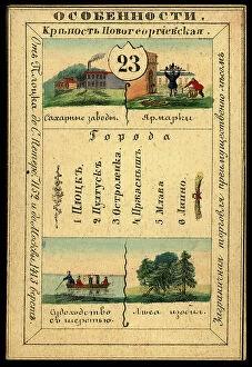
Bessarabia Province, 1856. Creator: UnknownBessarabia Province, 1856. This card is one of a souvenir set of 82 illustrated cards-one for each province of the Russian Empire as it existed in 1856
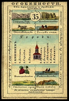
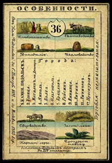
Kamenets-Podolsk Province, 1856. Creator: UnknownKamenets-Podolsk Province, 1856. This card is one of a souvenir set of 82 illustrated cards-one for each province of the Russian Empire as it existed in 1856
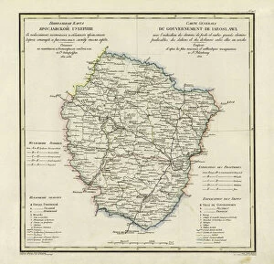
General Map of Yaroslavl Province: Showing Postal and Major Roads, Stations and the... 1822General Map of Yaroslavl Province: Showing Postal and Major Roads, Stations and the Distance in Versts between Them, 1822
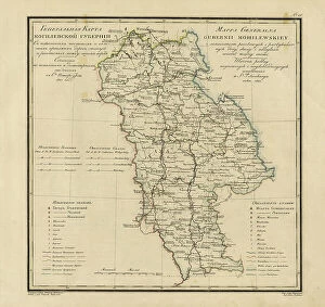
General Map of Mogilev Province: Showing Postal and Major Roads, Stations and... 1821General Map of Mogilev Province: Showing Postal and Major Roads, Stations and the Distance in Versts between Them, 1821. This 1821 map of Mogilev Provinceis from a larger work
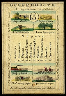
Saratov Province, 1856. Creator: UnknownSaratov Province, 1856. This card is one of a souvenir set of 82 illustrated cards-one for each province of the Russian Empire as it existed in 1856
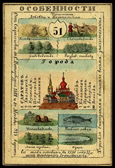
Tavastia Province, 1856. Creator: UnknownTavastia Province, 1856. This card is one of a souvenir set of 82 illustrated cards-one for each province of the Russian Empire as it existed in 1856
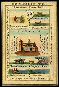
Samara Province, 1856. Creator: UnknownSamara Province, 1856. This card is one of a souvenir set of 82 illustrated cards-one for each province of the Russian Empire as it existed in 1856
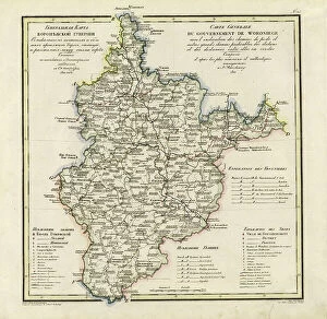
General Map of Voronezh Province: Showing Postal and Major Roads, Stations and the... 1822General Map of Voronezh Province: Showing Postal and Major Roads, Stations and the Distance in Versts between Them, 1822. This 1822 map of Voronezh Provinceis from a larger work
Kaunas Province, 1856. Creator: UnknownKaunas Province, 1856. This card is one of a souvenir set of 82 illustrated cards-one for each province of the Russian Empire as it existed in 1856
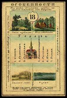
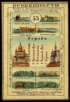
Astrakhan Province, 1856. Creator: UnknownAstrakhan Province, 1856. This card is one of a souvenir set of 82 illustrated cards-one for each province of the Russian Empire as it existed in 1856
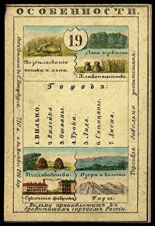
Vilnius Province, 1856. Creator: UnknownVilnius Province, 1856. This card is one of a souvenir set of 82 illustrated cards-one for each province of the Russian Empire as it existed in 1856
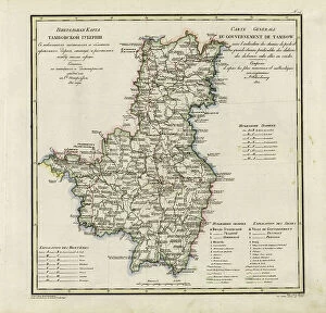
General Map of Tambov Province: Showing Postal and Major Roads, Stations and the... 1822General Map of Tambov Province: Showing Postal and Major Roads, Stations and the Distance in Versts between Them, 1822. This 1822 map of Tambov Provinceis from a larger work
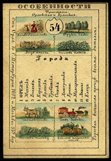
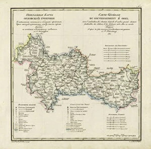
Orlov Province, 1856. Creator: UnknownOrlov Province, 1856. This card is one of a souvenir set of 82 illustrated cards-one for each province of the Russian Empire as it existed in 1856
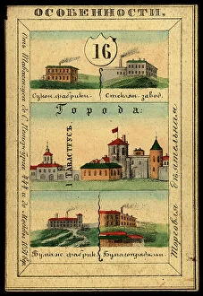
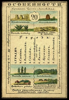
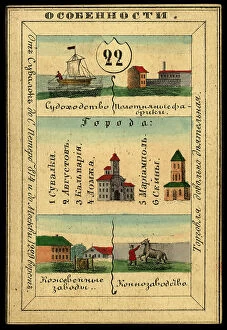
Grodno Province, 1856. Creator: UnknownGrodno Province, 1856. This card is one of a souvenir set of 82 illustrated cards-one for each province of the Russian Empire as it existed in 1856
General Map of the Polish Empire: Showing Postal and Major Roads, Stations and the... 1820General Map of the Polish Empire: Showing Postal and Major Roads, Stations and the Distance in Miles Between Them, 1820. This 1820 map of the Polish Empire, then part of the Russian Empire
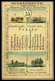
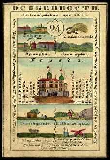
Kaluga Province, 1856. Creator: UnknownKaluga Province, 1856. This card is one of a souvenir set of 82 illustrated cards-one for each province of the Russian Empire as it existed in 1856
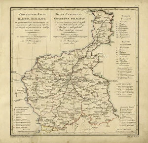
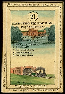
Kingdom of Poland, 1856. Creator: UnknownKingdom of Poland, 1856. This card is one of a souvenir set of 82 illustrated cards-one for each province of the Russian Empire as it existed in 1856
General Map of Kostroma Province: Showing Postal and Major Roads, Stations and... 1822General Map of Kostroma Province: Showing Postal and Major Roads, Stations and the Distance in Versts between Them, 1822. This 1822 map of Kostroma Provinceis from a larger work
Ryazan Province, 1856. Creator: UnknownRyazan Province, 1856. This card is one of a souvenir set of 82 illustrated cards-one for each province of the Russian Empire as it existed in 1856
Avgustov Province, 1856. Creator: UnknownAvgustov Province, 1856. This card is one of a souvenir set of 82 illustrated cards-one for each province of the Russian Empire as it existed in 1856
Courland Province, 1856. Creator: UnknownCourland Province, 1856. This card is one of a souvenir set of 82 illustrated cards-one for each province of the Russian Empire as it existed in 1856
General Map of Orel Province: Showing Postal and Major Roads, Stations and... 1822General Map of Orel Province: Showing Postal and Major Roads, Stations and the Distance in Versts between Them, 1822. This 1822 map of Orel Province is from a larger work
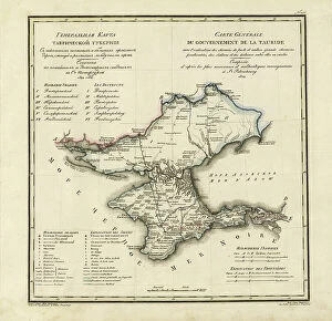
General Map of Taurida Province: Showing Postal and Major Roads, Stations and.. 1822General Map of Taurida Province: Showing Postal and Major Roads, Stations and the Distance in Versts between Them, 1822. This 1822 map ofTaurida Provinceis from a larger work
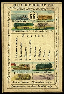
Arkhangelsk Province, 1856. Creator: UnknownArkhangelsk Province, 1856. This card is one of a souvenir set of 82 illustrated cards-one for each province of the Russian Empire as it existed in 1856
Plock Province, 1856. Creator: UnknownPlock Province, 1856. This card is one of a souvenir set of 82 illustrated cards-one for each province of the Russian Empire as it existed in 1856
General Map of Ryazan Province: Showing Postal and Major Roads, Stations and... 1822General Map of Ryazan Province: Showing Postal and Major Roads, Stations and the Distance in Versts between Them, 1822. This 1822 map of Ryazan Provinceis from a larger work
Vologoda Province, 1856. Creator: UnknownVologoda Province, 1856. This card is one of a souvenir set of 82 illustrated cards-one for each province of the Russian Empire as it existed in 1856
Warsaw Province, 1856. Creator: UnknownWarsaw Province, 1856. This card is one of a souvenir set of 82 illustrated cards-one for each province of the Russian Empire as it existed in 1856
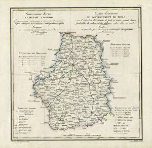
General Map of Tula Province: Showing Postal and Major Roads, Stations and... 1822General Map of Tula Province: Showing Postal and Major Roads, Stations and the Distance in Versts between Them, 1822. This 1822 map of Tula Provinceis from a larger work
Lifland Province, 1856. Creator: UnknownLifland Province, 1856. This card is one of a souvenir set of 82 illustrated cards-one for each province of the Russian Empire as it existed in 1856
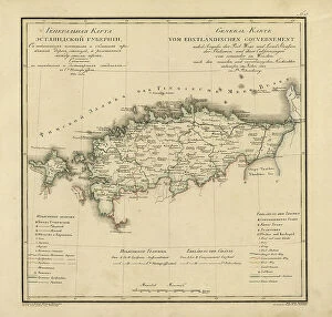
General Map of Estland Province: Showing Postal and Major Roads, Stations and... 1820General Map of Estland Province: Showing Postal and Major Roads, Stations and the Distance in Versts between Them, 1820. This 1820 map of Estland Province is from a larger work
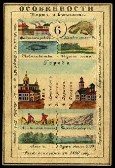
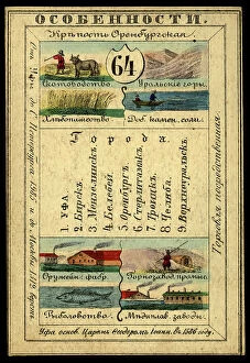
Orenburg Province, 1856. Creator: UnknownOrenburg Province, 1856. This card is one of a souvenir set of 82 illustrated cards-one for each province of the Russian Empire as it existed in 1856
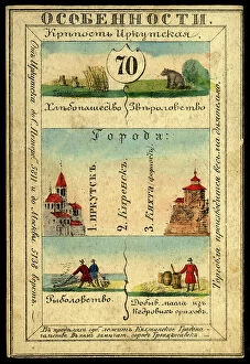
Irkutsk Province, 1856. Creator: UnknownIrkutsk Province, 1856. This card is one of a souvenir set of 82 illustrated cards-one for each province of the Russian Empire as it existed in 1856
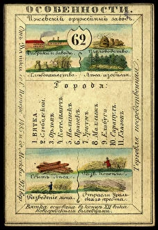
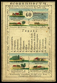
Vyatka Province, 1856. Creator: UnknownVyatka Province, 1856. This card is one of a souvenir set of 82 illustrated cards-one for each province of the Russian Empire as it existed in 1856
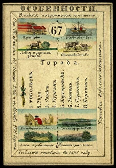
Tobolsk Province, 1856. Creator: UnknownTobolsk Province, 1856. This card is one of a souvenir set of 82 illustrated cards-one for each province of the Russian Empire as it existed in 1856
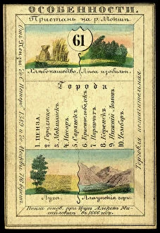
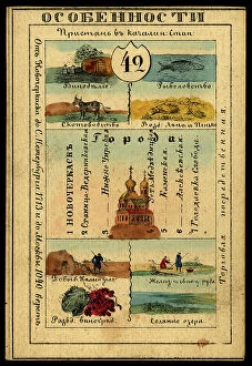
Penza Province, 1856. Creator: UnknownPenza Province, 1856. This card is one of a souvenir set of 82 illustrated cards-one for each province of the Russian Empire as it existed in 1856
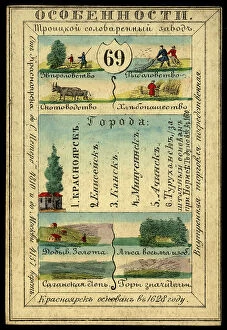
Enisei Province, 1856. Creator: UnknownEnisei Province, 1856. This card is one of a souvenir set of 82 illustrated cards-one for each province of the Russian Empire as it existed in 1856
Vladimir Province, 1856. Creator: UnknownVladimir Province, 1856. This card is one of a souvenir set of 82 illustrated cards-one for each province of the Russian Empire as it existed in 1856
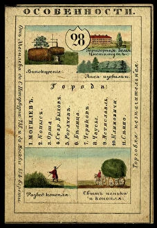
Mogilev Province, 1856. Creator: UnknownMogilev Province, 1856. This card is one of a souvenir set of 82 illustrated cards-one for each province of the Russian Empire as it existed in 1856
Land of the Don Cossacks, 1856. Creator: UnknownLand of the Don Cossacks, 1856. This card is one of a souvenir set of 82 illustrated cards-one for each province of the Russian Empire as it existed in 1856