mail_outline sales@mediastorehouse.com
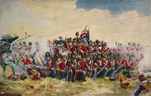
The Royal Scots. The Square at Quatre Bras, 1815, (1939). The Royal Scots form a square with bayonets fixed to repulse the French
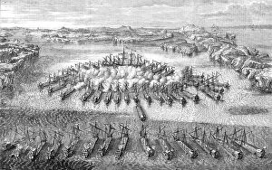
Naval Engagement between the Swedes and the Russians, at Hango Head, 1714 - from a Russian print of Creator: UnknownNaval Engagement between the Swedes and the Russians, at Hango Head, 1714 - from a Russian print of the time, 1856....a naval engagement between the Russians and the Swedes
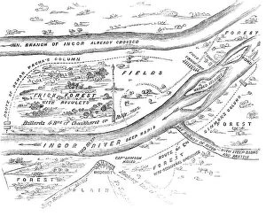
Plan of the Passage of the Ingour, 1856. Creator: UnknownPlan of the Passage of the Ingour, 1856. Crimean War: map showing...the ground on which Omer Pacha's late victory took place [and] the strategy by which he succeeded in forcing the passage of a
Au quartier general du roi de Roumanie; le roi Ferdinand et son fils aine, le prince... 1916. Creator: UnknownAu quartier general du roi de Roumanie; le roi Ferdinand et son fils aine, le prince Charles, etudiant la carte, 1916. From "Collection de la Guerre IV. L'Illustration Tome CXLVIII
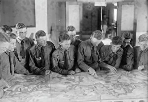
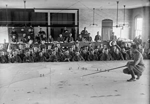
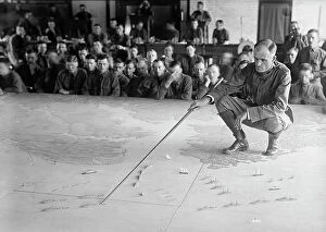
Military Training, 1917 or 1918. Creator: Harris & Ewing. Military Training, 1917 or 1918. Creator: Harris & EwingMilitary Training, 1917 or 1918
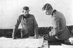
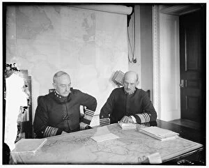
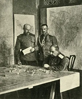
Benson and Mayo, between 1910 and 1920. Creator: Harris & Ewing. Benson and Mayo, between 1910 and 1920Benson and Mayo, between 1910 and 1920. US admirals William Shepherd Benson and Henry Thomas Mayo looking at a map of Mexico. Notepaper headed Office of Naval Operations'
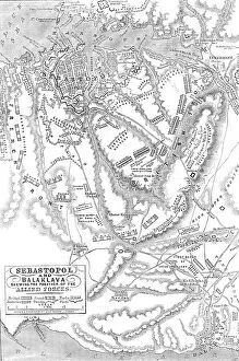
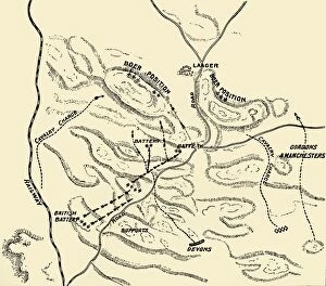
Sebastopol and Balaclava shewing the position of the Allied Forces, 1854. Creator: John DowerSebastopol and Balaclava shewing the position of the Allied Forces, 1854. Crimean War. The severe and costly battles of Balaclava and Inkerman
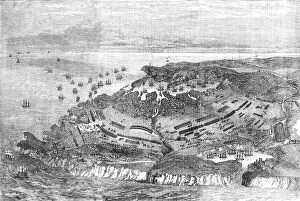
The Siege of Sebastopol - general view, 1854. Creator: UnknownThe Siege of Sebastopol - general view, 1854. Crimean War. Map showing the Russian-held ports of Sebastopol and Balaclava, harbours and warships
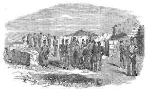
The Quarries Field, Head-Quarters of Lord Raglan, off Sebastopol, 1854. Creator: UnknownThe Quarries Field, Head-Quarters of Lord Raglan, off Sebastopol, 1854. Crimean War: Fitzroy HJ Somerset, 1st Baron Raglan, Master-General of the Ordnance of British Troops in the Crimea
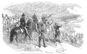
Lord Raglan and General Canrobert visiting the French Outposts opposite Sebastopol, 1854. Creator: UnknownLord Raglan and General Canrobert visiting the French Outposts opposite Sebastopol, 1854. Crimean War. General Canrobert...is looking at Sebastopol through his telescope...In the distance...may be
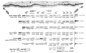
The Official Arrangement of the British Division off the coast of the Crimea, 1854. Creator: UnknownThe Official Arrangement of the British Division off the coast of the Crimea, 1854. Crimean War: plan of attack. Diagram showing the positions of Royal Navy ships carrying troops of the Light
The Siege of a Fortress. n. d. Creator: Albrecht DurerThe Siege of a Fortress.n.d
The French Forces: Louis XIII and Gaston d Orleans, ca. 1630. Creator: Abraham BosseThe French Forces: Louis XIII and Gaston d Orleans, ca. 1630
Plan of battle of Elandslaagte, 1900. Creator: UnknownPlan of battle of Elandslaagte, 1900. From " South Africa and the Transvaal War, Vol. II", by Louis Creswicke. [T. C. & E. C. Jack, Edinburgh, 1900]
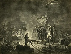
Napoleons bivouac on the battlefield of Wagram during the night of 5-6 July 1809, (1921). Napoleon la veille de Wagram. Napoleon Bonaparte (1769-1821), silhouetted against the campfire
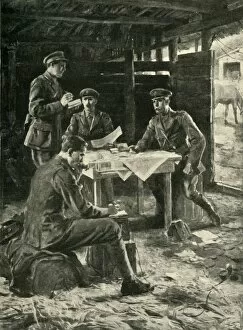
British officers on the Western Front, First World War, 1914-1918, (c1920). Creator: M UgoBritish officers on the Western Front, First World War, 1914-1918, (c1920). Directing an Attack on the British Front: scene at a brigade head-quarters
General Nikolai Yudenich, First World War, 1914-1918, (c1920). Creator: UnknownGeneral Nikolai Yudenich, First World War, 1914-1918, (c1920). The Grand Dukes Master Strategist: General Judenich, who planned the Russian campaigns in Asia Minor, Persia, and Mesopotamia
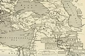
Map of Two and a Half Years Campaign in Mesopotamia, 1917. Creator: UnknownMap of Two and a Half Years Campaign in Mesopotamia, 1917. From " The War Illustrated Album De Luxe - Volume VIII. Ending The First Three Years", edited by J. A. Hammerton
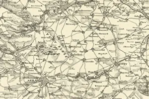
Detailed Map of the Arras Fighting Area, 1917. Creator: UnknownDetailed Map of the Arras Fighting Area, 1917. From " The War Illustrated Album De Luxe - Volume VIII. Ending The First Three Years", edited by J. A. Hammerton
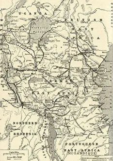
The Campaign in German East Africa, 1917. Creator: UnknownThe Campaign in German East Africa, 1917. From " The War Illustrated Album De Luxe - Volume VIII. Ending The First Three Years", edited by J. A. Hammerton
The Great Arras Battle Area, 1917. Creator: UnknownThe Great Arras Battle Area, 1917. From " The War Illustrated Album De Luxe - Volume VIII. Ending The First Three Years", edited by J. A. Hammerton
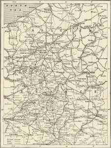
Map Showing German Retreat in the West, 1917, 1917. Creator: UnknownMap Showing German Retreat in the West, 1917, 1917. From " The War Illustrated Album De Luxe - Volume VIII. Ending The First Three Years", edited by J. A. Hammerton
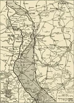
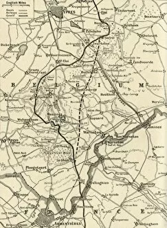
The Battle of Messines, 1917. Creator: UnknownThe Battle of Messines, 1917. From " The War Illustrated Album De Luxe - Volume VIII. Ending The First Three Years", edited by J. A. Hammerton. [The Amalgamated Press, Limited, London, 1917]
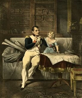
Le Cabinet de Napoleon, 19th century, (1921). Creator: UnknownLe Cabinet de Napoleon, 19th century, (1921). Napoleons Office. The emperor Napoleon and a child look at maps and discuss military strategy
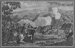
The Battle of Minden, or Thornhausen, in Westphalia... 1759, (1785). Creator: John GoldarThe Battle of Minden, or Thornhausen, in Westphalia, where the Alied [sic] Army, commanded by Prince Ferdinand of Brunswick-Wolfenbuttle, obtain d a Glorious Victory over the French Army
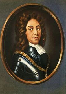
Eugen Prinz Von Savoyen, (1933). Creator: UnknownEugen Prinz Von Savoyen, (1933). Portrait of Prince Eugene of Savoy (1663-1736). Regarded as one of the outstanding military strategists of his time