mail_outline sales@mediastorehouse.com
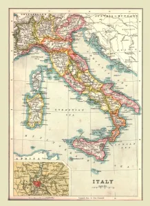
Map of Italy, 1902. Creator: UnknownMap of Italy, 1902. Showing the various administrative regions, the islands of Sardinia and Sicily, with inset of Rome. From The Century Atlas of the World. [John Walker & Co, Ltd. London, 1902]
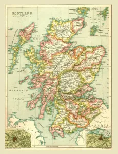
Map of Scotland, 1902. Creator: UnknownMap of Scotland, 1902. Showing the various counties and islands including the Hebrides, the Shetlands and the Orkneys, and an inset of the rail networks of Glasgow and Edinburgh
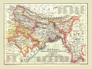
Map of Bengal, the North West and Central Provinces, and Assam, 1902. Creator: UnknownMap of Bengal, the North West and Central Provinces, and Assam, 1902. From The Century Atlas of the World. [John Walker & Co, Ltd. London, 1902]
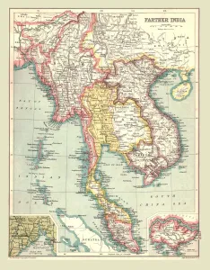
Map of Farther India, 1902. Creator: UnknownMap of Farther India, 1902. Southeast Asia, including Burma, Siam, Cambodia, French Indochina and Malaya. From The Century Atlas of the World. [John Walker & Co, Ltd. London, 1902]
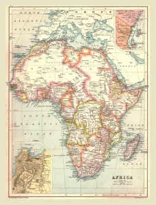
Map of Africa, 1902. Creator: UnknownMap of Africa, 1902. Showing colonial possessions including French West Africa and German South West Africa, with insets of Table Bay in South Africa, and British and German East Africa
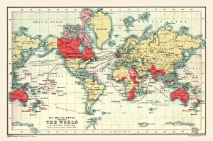
World Map showing the British Empire, 1902. Creator: UnknownWorld Map showing the British Empire, 1902. British possessions coloured red. From The Century Atlas of the World. [John Walker & Co, Ltd. London, 1902]
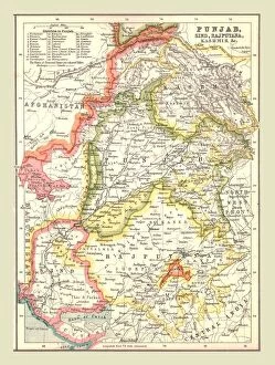
Map of Punjab, Sind, Rajputana and Kashmir, 1902. Creator: UnknownMap of Punjab, Sind, Rajputana and Kashmir, 1902. From The Century Atlas of the World. [John Walker & Co, Ltd. London, 1902]
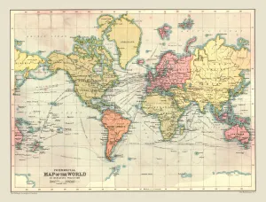
Commercial Map of the World, 1902. Creator: UnknownCommercial Map of the World, 1902. With shipping routes. From The Century Atlas of the World. [John Walker & Co, Ltd. London, 1902]
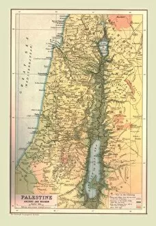
Map of Palestine, Ancient and Modern, 1902. Creator: UnknownMap of Palestine, Ancient and Modern, 1902. Showing the Mediterrean coast, Sea of Galilee and the Dead Sea. From The Century Atlas of the World. [John Walker & Co, Ltd. London, 1902]
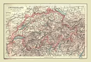
Map of Switzerland, 1902. Creator: UnknownMap of Switzerland, 1902. Showing mountains and lakes. From The Century Atlas of the World. [John Walker & Co, Ltd. London, 1902]
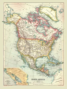
Map of North America, 1902. Creator: UnknownMap of North America, 1902. Showing the USA, Canada, Greenland, Central America and the Caribbean, with an inset of the Isthmus of Nicaragua. From The Century Atlas of the World
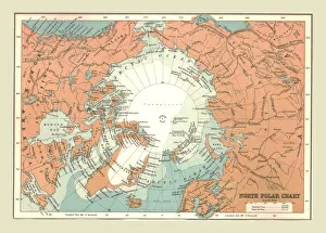
North Polar Chart, 1902. Creator: UnknownNorth Polar Chart, 1902. Showing the Arctic Circle. From The Century Atlas of the World. [John Walker & Co, Ltd. London, 1902]
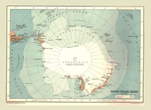
South Polar Chart, 1902. Creator: UnknownSouth Polar Chart, 1902. From The Century Atlas of the World. [John Walker & Co, Ltd. London, 1902]
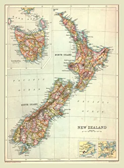
Map of New Zealand, 1902. Creator: UnknownMap of New Zealand, 1902. With insets of Tasmania and Auckland. From The Century Atlas of the World. [John Walker & Co, Ltd. London, 1902]
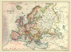
Map of Europe, 1902. Creator: UnknownMap of Europe, 1902. From The Century Atlas of the World. [John Walker & Co, Ltd. London, 1902]
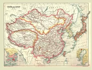
Map of China and Japan, 1902. Creator: UnknownMap of China and Japan, 1902. Showing Mongolia, Eastern Turkestan and Tibet, with insets of Hong Kong and Tokyo Bay. From The Century Atlas of the World. [John Walker & Co, Ltd. London, 1902]
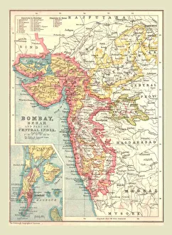
Map of Bombay, Berar, and part of Central India, 1902. Creator: UnknownMap of Bombay, Berar, and part of Central India, 1902. From The Century Atlas of the World. [John Walker & Co, Ltd. London, 1902]
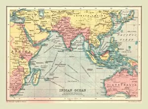
Map of the Indian Ocean, 1902. Creator: UnknownMap of the Indian Ocean, 1902. Showing the coast of East Africa, Arabia, the Indian subcontinent, the Far East and part of Australia. From The Century Atlas of the World. [John Walker & Co, Ltd
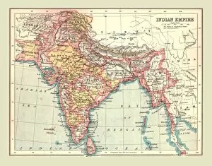
Map of the Indian Empire, 1902. Creator: UnknownMap of the Indian Empire, 1902. Showing the Indian subcontinent during the period of the British Raj (rule by the British Crown). From The Century Atlas of the World. [John Walker & Co, Ltd
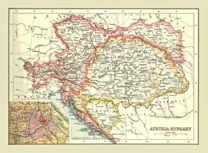
Map of Austria-Hungary, 1902. Creator: UnknownMap of Austria-Hungary, 1902. The Austro-Hungarian Empire including Bosnia, Transylvania, Bohemia, Dalmatia, Silesia, with inset of Vienna. From The Century Atlas of the World
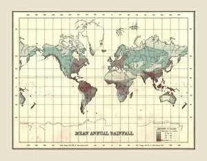
World Map showing Mean Annual Rainfall, 1902. Creator: UnknownWorld Map showing Mean Annual Rainfall, 1902. From The Century Atlas of the World. [John Walker & Co, Ltd. London, 1902]
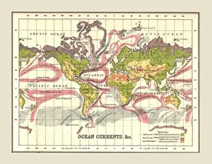
World Map showing Ocean Currents, 1902. Creator: UnknownWorld Map showing Ocean Currents, 1902. From The Century Atlas of the World. [John Walker & Co, Ltd. London, 1902]
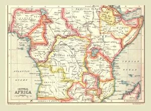
Map of Central Africa, 1902. Creator: UnknownMap of Central Africa, 1902. Showing colonial possessions including Italian Somaliland, Portuguese East Africa, German East Africa
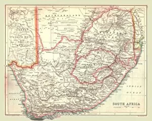
Map of South Africa, 1902. Creator: UnknownMap of South Africa, 1902. Showing the Cape Colony, Transvaal, Orange River Colony, and other colonial possessions including the British Protectorate of Bechuanaland, German South West Africa
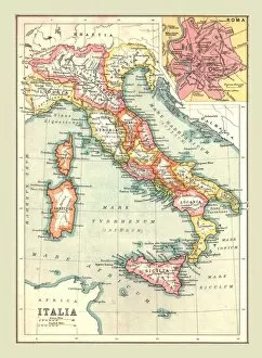
Map of Italia, (1902). Creator: UnknownMap of Italia, (1902). Showing the Italian peninsula during the Roman period, with place names in Latin, and inset of Rome. From The Century Atlas of the World. [John Walker & Co, Ltd. London, 1902]
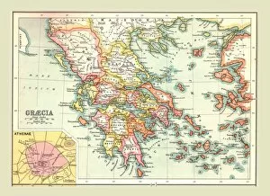
Map of Graecia, (1902). Creator: UnknownMap of Graecia, (1902). The provinces of Ancient Greece, with inset of Athens. From The Century Atlas of the World. [John Walker & Co, Ltd. London, 1902]
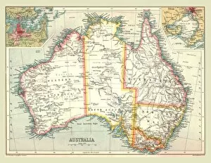
Map of Australia, 1902. Creator: UnknownMap of Australia, 1902. With insets of Sydney and Melbourne. From The Century Atlas of the World. [John Walker & Co, Ltd. London, 1902]
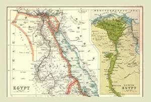
Map of Egypt, 1902. Creator: UnknownMap of Egypt, 1902. Showing the Red Sea and Sinai, with inset of the Nile delta. From The Century Atlas of the World. [John Walker & Co, Ltd. London, 1902]
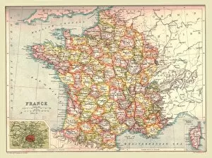
Map of France, 1902. Creator: UnknownMap of France, 1902. Showing the various administrative regions and departments, and insets of Corsica and Paris. From The Century Atlas of the World. [John Walker & Co, Ltd. London, 1902]
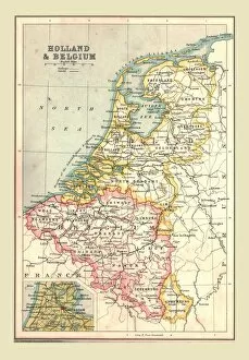
Map of Holland and Belgium, 1902. Creator: UnknownMap of Holland and Belgium, 1902. Showing the North Sea, and inset of Amsterdam. From The Century Atlas of the World. [John Walker & Co, Ltd. London, 1902]
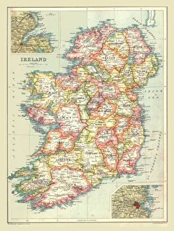
Map of Ireland, 1902. Creator: UnknownMap of Ireland, 1902. Showing the island of Ireland before the partition of the six counties which became Northern Ireland, with insets showing Dublin and Belfast
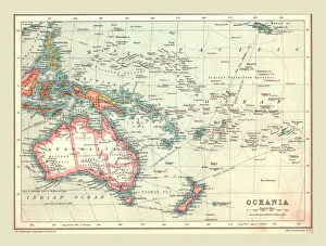
Map of Oceania, 1902. Creator: UnknownMap of Oceania, 1902. Showing Australia and New Zealand, and the East Indies Archipelago. From The Century Atlas of the World. [John Walker & Co, Ltd. London, 1902]
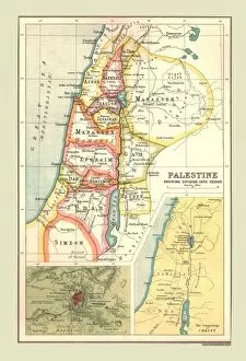
Map of Palestine, Showing Division into Tribes, (1902). Creator: UnknownMap of Palestine, Showing Division into Tribes, (1902). Map of the so-called Twelve Tribes of Israel, as referred to in the Hebrew Bible, with insets of Jerusalem and the Journeyings of Christ
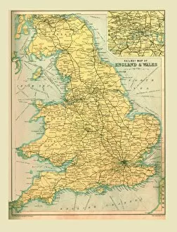
Railway Map of England and Wales, 1902. Creator: UnknownRailway Map of England and Wales, 1902. With inset showing stations in London. From The Century Atlas of the World. [John Walker & Co, Ltd. London, 1902]
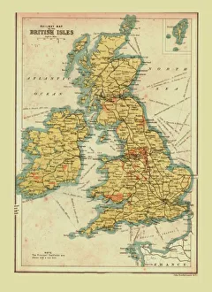
Railway Map of the British Isles, 1902. Creator: UnknownRailway Map of the British Isles, 1902. Showing the railway network across Britain and Ireland. From The Century Atlas of the World. [John Walker & Co, Ltd. London, 1902]
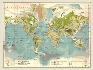
Map of the World showing Heights and Depths, 1902. Creator: UnknownMap of the World showing Heights and Depths, 1902. From The Century Atlas of the World. [John Walker & Co, Ltd. London, 1902]
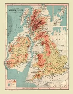
Physical Map of the British Isles, 1902. Creator: UnknownPhysical Map of the British Isles, 1902. Highest points shown in red. From The Century Atlas of the World. [John Walker & Co, Ltd. London, 1902]
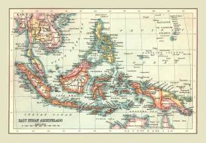
Map of the East Indian Archipelago, 1902. Creator: UnknownMap of the East Indian Archipelago, 1902. Showing Java, Sumatra, Borneo, Siam, The Philippines, Papua New Guinea and the South China Sea. From The Century Atlas of the World. [John Walker & Co, Ltd
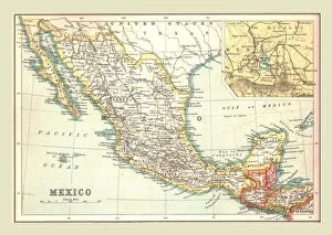
Map of Mexico, 1902. Creator: UnknownMap of Mexico, 1902. Showing Guatemala and British Honduras, with inset of Mexico City. From The Century Atlas of the World. [John Walker & Co, Ltd. London, 1902]
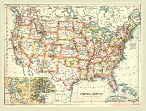
Map of the United States, 1902. Creator: UnknownMap of the United States, 1902. With insets of New York and San Francisco. From The Century Atlas of the World. [John Walker & Co, Ltd. London, 1902]
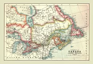
Map of the Dominion of Canada, Eastern Provinces, 1902. Creator: UnknownMap of the Dominion of Canada, Eastern Provinces, 1902. Showing Newfoundland, Nova Scotia, the Gulf of St Lawrence and the Great Lakes. From The Century Atlas of the World. [John Walker & Co, Ltd
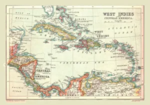
Map of the West Indies and Central America, 1902. Creator: UnknownMap of the West Indies and Central America, 1902. Showing the various Caribbean islands, and the north coast of South America. From The Century Atlas of the World. [John Walker & Co, Ltd
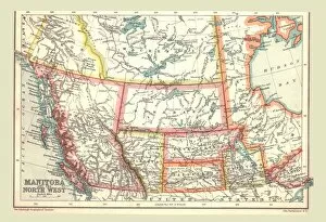
Map of Manitoba and the North West, 1902. Creator: UnknownMap of Manitoba and the North West, 1902. Showing the Pacific coast. From The Century Atlas of the World. [John Walker & Co, Ltd. London, 1902]
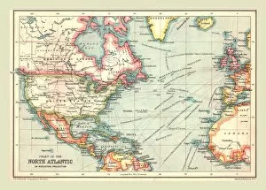
Chart of the North Atlantic, 1902. Creator: UnknownChart of the North Atlantic, 1902. Showing North and Central America, West Africa and Western Europe, and transatlantic shipping routes. From The Century Atlas of the World. [John Walker & Co, Ltd
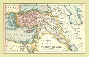
Map of Turkey in Asia, 1902. Creator: UnknownMap of Turkey in Asia, 1902. Showing the eastern Mediterranean, the coast of Egypt and parts of the Middle East. From The Century Atlas of the World. [John Walker & Co, Ltd. London, 1902]
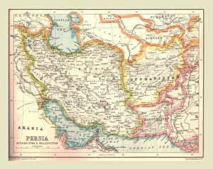
Map of Persia, 1902. Creator: UnknownMap of Persia, 1902. Showing Persia, Afghanistan and Baluchistan, and the Persian Gulf. From The Century Atlas of the World. [John Walker & Co, Ltd. London, 1902]
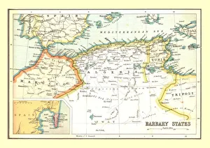
Map of the Barbary States, 1902. Creator: UnknownMap of the Barbary States, 1902. Showing Morocco, Algeria, Tunisia, and Libya on the North African coast, with inset of Gibraltar. From The Century Atlas of the World. [John Walker & Co, Ltd
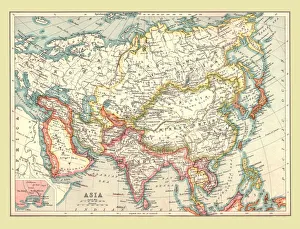
Map of Asia, 1902. Creator: UnknownMap of Asia, 1902. Showing Arabia, Persia, the Indian Subcontinent, Indochina and the Chinese Empire. From The Century Atlas of the World. [John Walker & Co, Ltd. London, 1902]