mail_outline sales@mediastorehouse.com
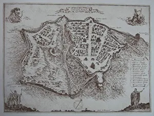
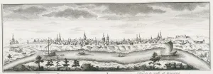
Nesvizh, 1604. Artist: Makowski, Tomasz (c. 1575-c. 1630)Nesvizh, 1604. Found in the collection of the National Museum Palace of the Grand Dukes of Lithuania
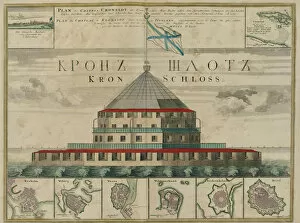
Plan of the Kronstadt Fortress, 1750. Artist: Homann, Johann Baptist (1663-1724)Plan of the Kronstadt Fortress, 1750. From a private collection
Rugen (From: Theatrum Orbis Terrarum... ), 1645. Artist: Blaeu, Willem Janszoon (1571-1638)Rugen (From: Theatrum Orbis Terrarum...), 1645. Found in the collection of the UCLA Library
Russia Moscovia, c. 1565. Artist: Danti, Egnazio (1536-1586)Russia Moscovia, c. 1565. Found in the collection of the Palazzo Vecchio, Florence
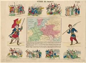
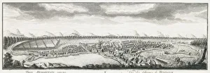
Polish war, 1831. Artist: AnonymousPolish war, 1831. From a private collection
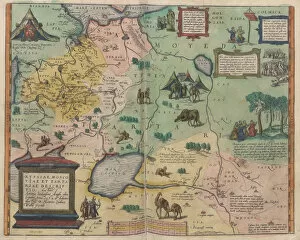
Map of Russia (From: Rerum Moscoviticarum commentarii ), 1556. Artist: AnonymousMap of Russia (From: Rerum Moscoviticarum commentarii..), 1556. Found in the collection of the State History Museum, Moscow
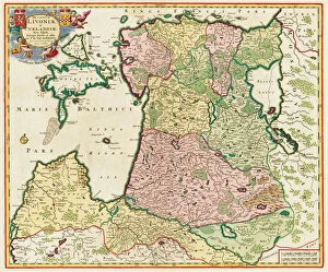
The Baltic Sea (From: Ducatuum Livoniae et Curlandiae Nova Tabula), 1705. Artist: Anonymous masterThe Baltic Sea (From: Ducatuum Livoniae et Curlandiae Nova Tabula), 1705. From a private collection
Map of Poltava in the early 18th-century. Artist: AnonymousMap of Poltava in the early 18th-century. Found in the collection of the State Open-air Museum Battle of Poltava, Poltava
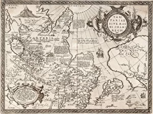
Map of Russia (From: Theatrum Orbis Terrarum), 1573. Artist: Ortelius, Abraham (1527-1598)Map of Russia (From: Theatrum Orbis Terrarum), 1573. From a private collection
The Battle of Viborg Bay, 1790 (Map), 1790. Artist: Gillberg, Jacob (1724-1793)The Battle of Viborg Bay, 1790 (Map), 1790. From a private collection
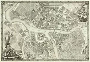
Map of Petersburg (Book to the 50th anniversary of the founding of St. Petersburg), 1753. Artist: Russian MasterMap of Petersburg (Book to the 50th anniversary of the founding of St. Petersburg), 1753. Found in the collection of the Russian National Library, St. Petersburg
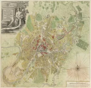
Map of Moscow, 1739. Artist: Michurin, Ivan Fyodorovich (1700-1763)Map of Moscow, 1739. Found in the collection of the Russian State Archives of Ancient Documents (RGADA)
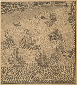
Peter the Greats Fleet at the Onega Bay, ca 1707. Artist: AnonymousPeter the Greats Fleet at the Onega Bay, ca 1707. Private Collection
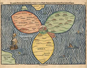
The three continents with Jerusalem in the center of the World, 1581. Artist: Bunting, Heinrich (1545-1606)The three continents with Jerusalem in the center of the World, 1581. Private Collection
The Buddhist world map, 1710. Artist: Rokashi Hotan, Zuda (1654-1738)The Buddhist world map, 1710. Private Collection
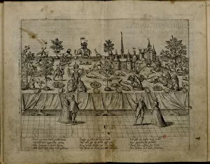
The Wedding of Duke John William of Julich-Cleves-Berg and Jakobea of Baden, 1585. Artist: Hogenberg, Frans (1535-1590)The Wedding of Duke John William of Julich-Cleves-Berg and Jakobea of Baden, 1585. Private Collection
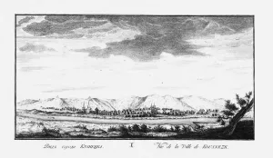
View of Krasnoyarsk, ca 1735. Artist: Lursenius, Johann Wilhelm (1704-1771)View of Krasnoyarsk, ca 1735. Private Collection
View of Ilimsk, ca 1735. Artist: Lursenius, Johann Wilhelm (1704-1771)View of Ilimsk, ca 1735. Private Collection
View of Kuznetsk, ca 1735. Artist: Lursenius, Johann Wilhelm (1704-1771)View of Kuznetsk, ca 1735. Private Collection
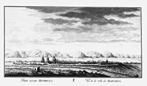
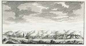
View of Tara, ca 1735. Artist: Lursenius, Johann Wilhelm (1704-1771)View of Tara, ca 1735. Private Collection
View of Nerchinsk, ca 1735. Artist: Lursenius, Johann Wilhelm (1704-1771)View of Nerchinsk, ca 1735. Private Collection
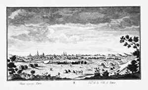
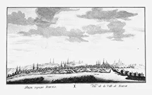
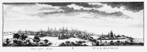
View of Tomsk, ca 1735. Artist: Lursenius, Johann Wilhelm (1704-1771)View of Tomsk, ca 1735. Private Collection
View of Yakutsk, ca 1735. Artist: Lursenius, Johann Wilhelm (1704-1771)View of Yakutsk, ca 1735. Private Collection
View of the fortress of Udinskoye, ca 1735. Artist: Lursenius, Johann Wilhelm (1704-1771)View of the fortress of Udinskoye, ca 1735. Private Collection
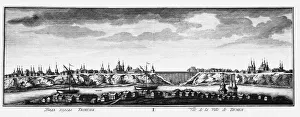
View of Tyumen, ca 1735. Artist: Lursenius, Johann Wilhelm (1704-1771)View of Tyumen, ca 1735. Private Collection
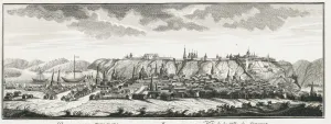
View of Tobolsk, ca 1735. Artist: Lursenius, Johann Wilhelm (1704-1771)View of Tobolsk, ca 1735. Private Collection
View of Nevyansk factories, ca 1735. Artist: Lursenius, Johann Wilhelm (1704-1771)View of Nevyansk factories, ca 1735. Private Collection
View of Yeniseysk, ca 1735. Artist: Lursenius, Johann Wilhelm (1704-1771)View of Yeniseysk, ca 1735. Private Collection
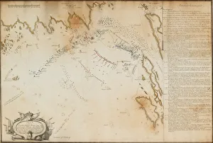
View and Map of the Affair at Ratan, on August 20, 1809, 1809. Artist: Gillberg, Carl Gustaf (1774-1855)View and Map of the Affair at Ratan, on August 20, 1809, 1809. Found in the collection of National Library of Sweden
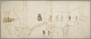
The Map of the First Kamchatka Expedition, 1725-1730. Artist: Bering, Vitus Jonassen (1681-1741)The Map of the First Kamchatka Expedition, 1725-1730. Found in the collection of National Library of Sweden
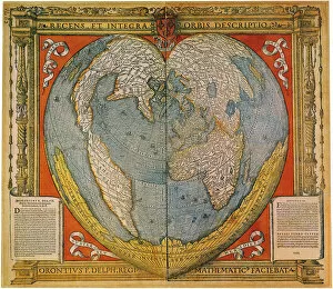
Heart Shaped World Map. Artist: Fine, Oronce (1494-1555)Heart Shaped World Map. Found in the collection of Bibliotheque Nationale de France
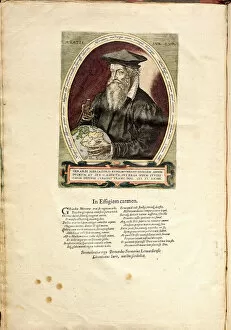
Portrait of Gerardus Mercator (1512-1594) aged 62. Artist: Hogenberg, Frans (1535-1590)Portrait of Gerardus Mercator (1512-1594) aged 62. Private Collection
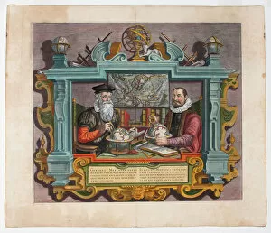
Double Portrait of Gerardus Mercator (1512-1594) and Jodocus Hondius (1563-1612). Found in the collection of Academy of Sciences, Saint Petersburg
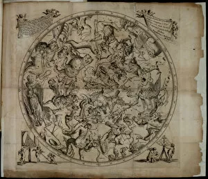
Table of the constellation of the Northern Hemisphere (Firmamentum Sobiescianumsive Uranographia). Private Collection
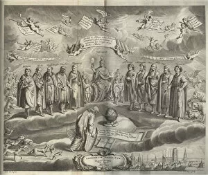
Firmamentum Sobiescianumsive Uranographia (Frontispiece). Artist: Hevelius, Johannes (1611-1687)Firmamentum Sobiescianumsive Uranographia (Frontispiece). Private Collection
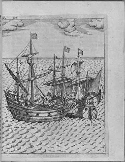
Battle between Francis Drakes ship Golden Hind and the Spanish ship Cacafuego. (From Levinus Hulsiu Artist: Anonymous)Battle between Francis Drakes ship Golden Hind and the Spanish ship Cacafuego. (From Levinus Hulsiuss Beschreibung..), 1626. From a private collection
Title page of Americae Pars VIII (with a portrait of Francis Drake and his ship, the Golden Hind), 1 Artist: BryTitle page of Americae Pars VIII (with a portrait of Francis Drake and his ship, the Golden Hind), 1598-1599. From a private collection
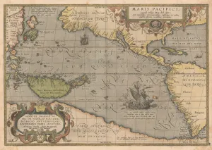
Maris Pacifici (From Theatrum orbis terrarum), 1595. Artist: Ortelius, Abraham (1527-1598)Maris Pacifici (From Theatrum orbis terrarum), 1595. From a private collection
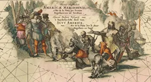
Tractus australior Americae Meridionalis, a Rio de la Plata per Fretum Magellanicum ad Toraltum (deta Artist: Wit)Tractus australior Americae Meridionalis, a Rio de la Plata per Fretum Magellanicum ad Toraltum (detail), 1675. From a private collection
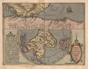
Chica sive Patagonica et Australis Terra (From Geographisches Handtbuch), 1600. Artist: Quad, Matthias (1557-1613)Chica sive Patagonica et Australis Terra (From Geographisches Handtbuch), 1600. From a private collection
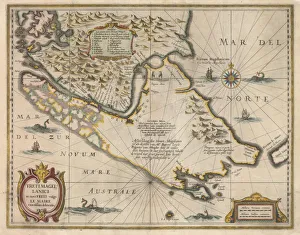
Freti Magellanici ac novi freti vulgo Le Maire exactissima delineatio, c. 1630. Artist: Hondius, Jodocus (1563-1612)Freti Magellanici ac novi freti vulgo Le Maire exactissima delineatio, c.1630. From a private collection
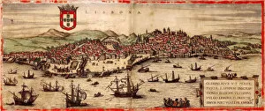
View of Lisbon and Tagus River (From: Civitates Orbis Terrarum), 1572. Artist: Hogenberg, Frans (1535-1590)View of Lisbon and Tagus River (From: Civitates Orbis Terrarum), 1572. Found in the collection of the University Library Heidelberg
The Floating batteries at the Siege of Kinburn 1855-1856, 1856. Artist: AnonymousThe Floating batteries at the Siege of Kinburn 1855-1856, 1856. From a private collection
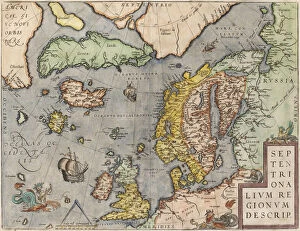
The Baltic Sea (From: Theatrum Orbis Terrarum), c. 1608-1610. Artist: Ortelius, Abraham (1527-1598)The Baltic Sea (From: Theatrum Orbis Terrarum), c. 1608-1610. From a private collection
Map of Russia (From: Theatrum Orbis Terrarum), 1598. Artist: Ortelius, Abraham (1527-1598)Map of Russia (From: Theatrum Orbis Terrarum), 1598. From a private collection
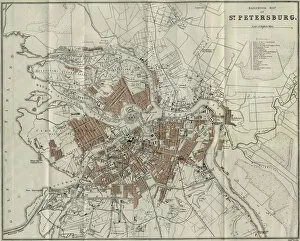
Map of Petersburg, 1893. Artist: Anonymous masterMap of Petersburg, 1893. From a private collection
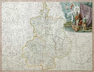
Map of Voronezh Governorate, 1792. Artist: Wilbrecht (Wildbrecht), Alexander (1757-1823)Map of Voronezh Governorate, 1792. Found in the collection of the Regional I. Kramskoi Art Museum, Voronezh
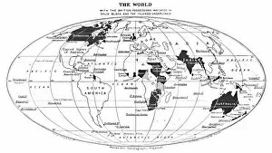
The World with the British Possessions Indicated in Solid Black and the Islands Underlined, 1924. From The British Empire in Pictures, by H. Clive Barnard, M.A. B.Litt. [A. & C