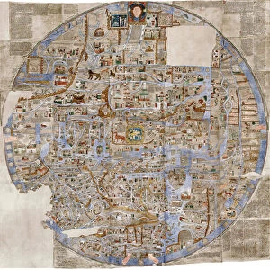
Hereford World Map, c. 1280, 1944. Creator: Richard de Bello

![]()
Wall Art and Photo Gifts from Heritage Images
Hereford World Map, c. 1280, 1944. Creator: Richard de Bello
Hereford World Map, c.1280, (1944). Detail showing the Mediterranean coast and the Nile Delta in northern Egypt. The lighthouse at Alexandria, complete with flames, can be seen next to the mouth of the River Nile. Also shown are mythical creatures such as the winged salamander, unicorn or monoceros, and mandragora, as well as a real rhinoceros. Part of the Hereford Mappa Mundi at Hereford Cathedral. Attributed to Richard de Bello, the Hereford Mappa Mundi, drawn on a single sheet of vellum, is the largest known existing medieval map. From " British Maps and Map-Makers", by Edward Lynam. [Collins, London, 1944]
Media ID 19777276
© The Print Collector/Heritage Images
Alexandria Amphibian Britain In Pictures Collins Edward Edward Lynam Island Islands Largest Latin Lighthouse Lynam Mediterranean Sea Nile Nile Delta North Africa Rhino Rhinoceros Richard De River Nile Salamander Social History The Nile Unicorn William Collins William Collins And Sons William Collins Sons
MADE IN THE UK
Safe Shipping with 30 Day Money Back Guarantee
FREE PERSONALISATION*
We are proud to offer a range of customisation features including Personalised Captions, Color Filters and Picture Zoom Tools
SECURE PAYMENTS
We happily accept a wide range of payment options so you can pay for the things you need in the way that is most convenient for you
* Options may vary by product and licensing agreement. Zoomed Pictures can be adjusted in the Basket.