mail_outline sales@mediastorehouse.com
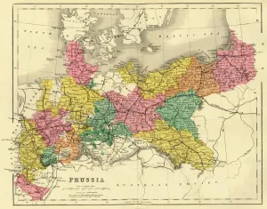
Map of Prussia, c1872. Creator: UnknownMap of Prussia, c1872. Showing the various regions including Holstein, Hanover, Westphalia, Lower Rhine, Lorraine, Nassau, Cassel, Saxony, Brandedburg, Silesia, Pomerania, West Prussia
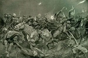
The Night Charge of the 19th Hussars Near Lydenberg on Nov. 7th 1900, 1901. CreatorThe Night Charge of the 19th Hussars Near Lydenberg on Nov. 7th 1900, 1901. From " South Africa and the Transvaal War, Vol. VI", by Louis Creswicke. [T. C. & E. C. Jack, Edinburgh, 1901]
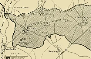
Map showing approximately the area gained on the Thiepval Ridge... 1916, (c1920)Map showing approximately the area gained on the Thiepval Ridge between September 14 and October 31, 1916, (c1920). The British line in northern France during the Battle of the Somme
The War in Denmark: view of Aalborg, in Jutland, now occupied by the Prussian army, 1864. Creator: UnknownThe War in Denmark: view of Aalborg, in Jutland, now occupied by the Prussian army, 1864. Engraving of a sketch '...by Mr. C
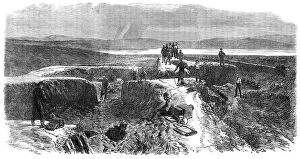
Illustrations of the War in Denmark: interior of No. 4 Redoubt at Düppel, 1864. Creator: UnknownIllustrations of the War in Denmark: interior of No. 4 Redoubt at Duppel, 1864. Engraving '...from a sketch by our Special Artist...[showing] the aspect of Duppel since the storm of war has swept
The War in Denmark: rear view of the Düppel position, from the Church Battery, Sonderburg, 1864. Creator: UnknownThe War in Denmark from a sketch by our special artist: rear view of the Duppel position, from the Church Battery, Sonderburg, 1864
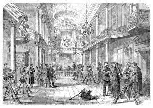
The War in Schleswig: distributing medals to Austrian troops at Hoptrup..., 1864. Creator: UnknownThe War in Schleswig: distributing medals to Austrian troops at Hoptrup - from a sketch by our special artist, 1864. The Sketch...was taken at Hoptrup
The War in Schleswig: chapel at Gravenstein used as a Prussian barrack..., 1864. Creator: UnknownThe War in Schleswig: chapel at Gravenstein [in Denmark] used as a Prussian barrack - from a sketch by our special artist, 1864
Destruction of the fortifications of the Ionian Islands: Fort Neuf, in the harbour of Corfu, 1864. Creator: UnknownDestruction of the fortifications of the Ionian Islands: Fort Neuf, in the harbour of Corfu, 1864. 'The conduct of her Majesty's Government in demolishing the fortifications of Corfu before handing
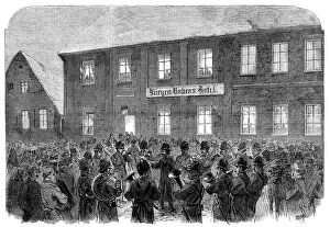
The War in Schleswig: band playing before Marshal Wrangel's head-quarters at Hadersleben..., 1864. Creator: UnknownThe War in Schleswig: band playing before Marshal Wrangel's head-quarters at Hadersleben - from a sketch by our special artist, 1864
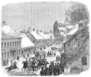
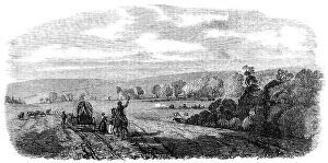
The War in Denmark: Kolding, Jutland, the head-quarters of the Allied armies..., 1864. Creator: UnknownThe War in Denmark: Kolding, Jutland, the head-quarters of the Allied armies - from a sketch by our special artist, 1864. 'This small town, which has but four thousand inhabitants
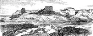
The War in New Zealand: stronghold of the Maoris at Rangariri, 1864. Creator: UnknownThe War in New Zealand: stronghold of the Maoris at Rangariri, 1864. Engraving from a photograph, of the scene of '...General Cameron's victory on the 20th of November...The British troops...first
The War in Schleswig: High-Street, Hadersleben - from a sketch by our special artist, 1864. Creator: UnknownThe War in Schleswig: High-Street, Hadersleben - from a sketch by our special artist, 1864. View of '...the principal street of Hadersleben
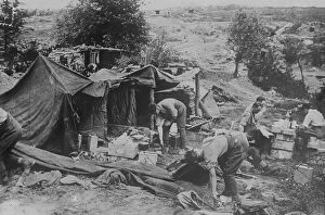
British artillery officers mess on captured ground, 10 Jun 1917. Creator: Bain News ServiceBritish artillery officers mess on captured ground, 10 Jun 1917. British artillery officers mess tent in front of Kemmel, Belgium, June 10, 1917, during the Battle of Messines during World War I
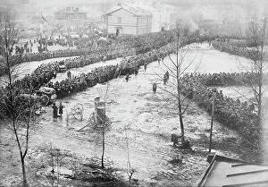
15000 Russian prisoners at Augustow, Feb 1915. Creator: Bain News Service15000 Russian prisoners at Augustow, Feb 1915. Russian prisoners under German control in Augusto´w, now northeast Poland during World War I
Russian Church at Suwalki in German hands, between c1914 and c1915. Creator: Bain News ServiceRussian Church at Suwalki in German hands, between c1914 and c1915. German soldiers outside a Russian church in Suwalki, Poland during World War I
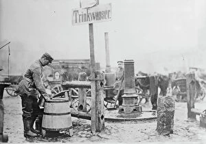
German Sanitary sign near Lodz, between 1914 and c1915. Creator: Bain News ServiceGerman Sanitary sign near Lodz, between 1914 and c1915. A sign in German "Trinkwasser" (drinking water) next to a pump in Lodz, Poland during World War I
Siberian prisoners of Germans in Lodz, between 1914 and c1915. Creator: Bain News ServiceSiberian prisoners of Germans in Lodz, between 1914 and c1915. Siberian prisoners of German forces in Lodz, Poland, probably during or after the Battle of Lodz during World War I
General view of the Chincha Islands, lately seized by the Spaniards, 1864. Creator: UnknownGeneral view of the Chincha Islands, lately seized by the Spaniards, 1864. Engraving from a sketch by Oswald Younghusband
Germans in a town in Russian Poland holding religious service, between 1914 and c1915. Creator: Bain News ServiceGermans in a town in Russian Poland holding religious service, between 1914 and c1915. German soldiers holding a service in Poland during World War I
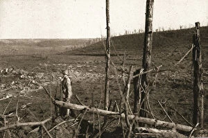
Recaptured Territory; On the right, in the background, the remains of Allemant... 1917. Creator: UnknownRecaptured Territory; On the right, in the background, the remains of Allemant; halfway up the hillside on the left, the Thomas quarries where two whole German battalions were captured; on the right
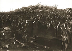
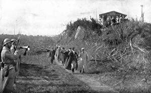
In Recaptured Territory; The evening of October 23, 1917: gathering German prisoners, ... 1917. Creator: UnknownIn Recaptured Territory; The evening of October 23, 1917: gathering German prisoners in what was the main courtyard of the Chateau de Lamotte, near Allemant, 1917
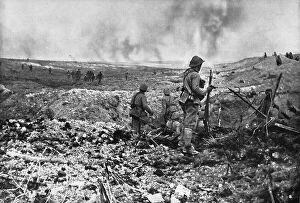
In Champagne: a surprise attack; While part of the group held back to clear the ground... 1917. Creator: UnknownIn Champagne: a surprise attack; While part of the group held back to clear the ground taken in the first wave, the forward line marched to the second enemy line whose survivors had surrendered
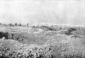
At Le Mort Homme; The recaptured ridge of Mort-Homme, 1917. Creator: UnknownAt Le Mort Homme; The recaptured ridge of Mort-Homme, 1917. From "L'Album de la Guerre 1914-1919, Volume 2" [L'Illustration, Paris, 1924].Execution Date: 1924 - 1924
President of the Portuguese Republic on the front; Traveling through liberated region... 1917. Creator: UnknownPresident of the Portuguese Republic on the front; Traveling through liberated regions from Oise to Nesle, the President is taken to the former observation post of Prince Eitel of Prussia
Sioux village near Fort Laramie; Ocean to Ocean, the Pacific railroad, 1875. Creator: Frederick WhymperSioux village near Fort Laramie; Ocean to Ocean, the Pacific railroad, 1875. From, Illustrated Travels by H.W. Bates. [Cassell, Petter, and Galpin, c1880, London]
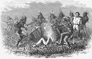
Sioux Indians burning a prisoner; Ocean to Ocean, the Pacific railroad, 1875. Creator: Frederick WhymperSioux Indians burning a prisoner; Ocean to Ocean, the Pacific railroad, 1875. From, Illustrated Travels by H.W. Bates. [Cassell, Petter, and Galpin, c1880, London]
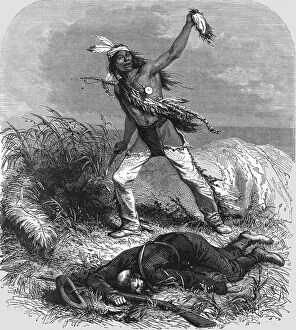
The exultant Indians mutilate the dead body; Passage of the Great Canon of the Colorado, 1875. Creator: A. R CalhounThe exultant Indians mutilate the dead body; Passage of the Great Canon of the Colorado, 1875. From, Illustrated Travels by H.W. Bates. [Cassell, Petter, and Galpin, c1880, London]
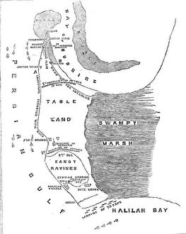
Plan of the Operations against Bushire, 1857. Creator: UnknownPlan of the Operations against Bushire, 1857. Map showing Persian Gulf, tableland, sandy ravines, swampy marsh, Halilah Bay
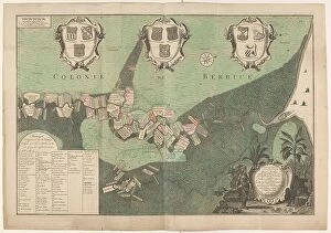
Accurate Map of the state and the course of Rio de Berbice... 1742. Creators: Jan Daniel Knapp, Hendrik de LethAccurate Map of the state and the course of Rio de Berbice. Located with the same Plantation in the Colony of Berbice, 1742
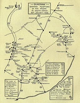
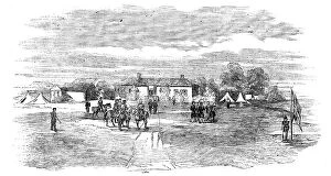
Diagram Showing Positions of the Troops in South Africa, 31st January 1900, (c1900). Creator: UnknownDiagram Showing Positions of the Troops in South Africa, 31st January 1900, (c1900). Boer Wars. Map showing lines of communication and the positions of the British and the Boers
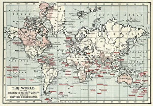
The World at the Beginning of the 20th Century Showing British Possessions, c1900. Creator: Artists Illustrators LtdThe World at the Beginning of the 20th Century Showing British Possessions [in pink], c1900. From "Cassell's History of England, Vol. IX"
Sebastopol - North Side - sketched by J. A. Crowe, 1856. Creator: J. A. CroweSebastopol - North Side - sketched by J. A. Crowe, 1856. Crimean War: The position of the Russians on the north side of the harbour of Sebastopol...has remained without any alteration for the last
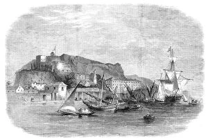
The Island of Karrak, in the Persian Gulf, 1857. Creator: UnknownThe Island of Karrak, in the Persian Gulf, 1857. Engraving after a sketch by Mr. A. Harrison, Master, Indian Navy...The Island of Karrak...is situated thirty miles W.N.W
Allegory on the French Invasion of 1672, 1672. Creator: Johannes van WijckerslootAllegory on the French Invasion of 1672, 1672
The Nebraska and Kansas Territory: Settlers entering Nebraska, Pappea Creek, 1856. Creator: UnknownThe Nebraska and Kansas Territory: Settlers entering Nebraska, Pappea Creek, 1856. View of...extensive unoccupied territory of the United States...[which] hitherto has been the home of the crafty
The Nebraska and Kansas Territory: Ancient Bluff Ruins, Nebraska, 1856. Creator: UnknownThe Nebraska and Kansas Territory: Ancient Bluff Ruins near Fort Larumie [sic], Nebraska, 1856. View of...extensive unoccupied territory of the United States...[which] hitherto has been the home of
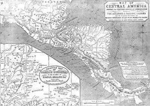
Map of Central America shewing the Proposed Routes of Communication between the Atlantic & Pacific O CreatorMap of Central America shewing the Proposed Routes of Communication between the Atlantic & Pacific Oceans, 1856....and the Disputed Territories of British Honduras (Belize)
View of the Sacco Valley southeast of Olevano. The Volsci Montains can be Seen in the Background, 1869
The Seconda Macchina for the Chinea of 1746: The Territories of the Kingdom of Naples, 1746. Creator: M SorelloThe Seconda Macchina for the Chinea of 1746: The Territories of the Kingdom of Naples, 1746
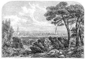
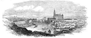
Abo, from an original sketch, 1854. Creator: UnknownAbo, from an original sketch, 1854. Abo [now Turku] is the most ancient city in Finland; its history being coeval with the reign of Eric the Saint, that is from about 1150 to 1160
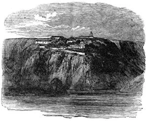
Monastery of St. George, near Balaclava - from a sketch by Lieut. Montagu O'Reilly, 1854. Creator: UnknownMonastery of St. George, near Balaclava - from a sketch by Lieut. Montagu O'Reilly, 1854. The monastery of St. George hangs, as it were, to the face of the cliff
Russian Steamers Shelling the French Camp, Sebastopol, 1854. Creator: UnknownRussian Steamers Shelling the French Camp, Sebastopol, 1854. Crimean War. Sketch by Lieutenant Edgar G. Bredin, Royal Artillery, ...taken from a French redoubt
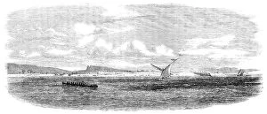
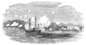
The "Valorous" chasing Russian Steamers into Sebastopol, 1854. Creator: UnknownThe "Valorous" chasing Russian Steamers into Sebastopol, 1854. Crimean War....the mast-heads of a Russian steamer appeared... another was seen following her
Head-Quarters of Lord Raglan, near Balaclava - from a sketch by Lieutenant Montagu O'Reilly, 1854. Creator: UnknownHead-Quarters of Lord Raglan, near Balaclava - from a sketch by Lieutenant Montagu O'Reilly, 1854. Crimean War. View of...the Head-quarters of Lord Raglan, not far from Balaclava
French Ambulances, before Sebastopol, 1854. Creator: UnknownFrench Ambulances, before Sebastopol, 1854. Crimean War:.nearly all English accounts from the Crimea represent the French medical arrangements as much superior to those of our army
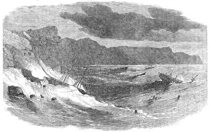
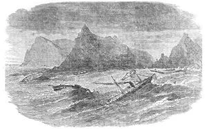
Storm in Balaclava Bay, 1854. Creator: UnknownStorm in Balaclava Bay, 1854. Crimean War: Royal Navy ships lost in bad weather on the Black Sea. Captain Frain saving the sole survivor from the Wild Wave; Pride of Ocean; HMS Retribution; Medora;
Storm in Balaclava Bay, 1854. Creator: UnknownStorm in Balaclava Bay, 1854. Crimean War: Royal Navy ships lost in bad weather on the Black Sea. Ship Caducis; Ship Progress; Maltese Brig; Steamer Melbourne; HMS Avon; HMS Vesuvius; Wild Wave; Ship