mail_outline sales@mediastorehouse.com
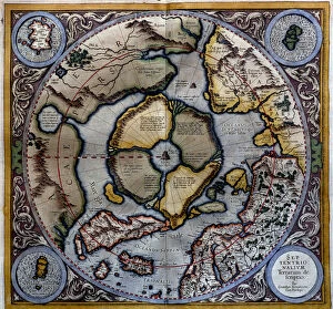
Atlas of Gerardus Mercator, 1595, map of the Arctic to the North Pole and surrounding lands within and outside the Arctic Circle
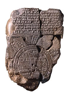
The Babylonian Map of the World, c. 510-c. 500 BC. Artist: Assyrian ArtThe Babylonian Map of the World, c. 510-c. 500 BC. Found in the collection of British Museum
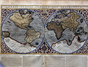
Atlas of Gerardus Mercator, 1595. World Map
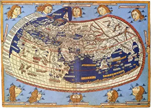
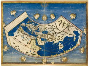
Ptolemy World map, 1467. Found in the collection of Biblioteka Narodowa, Warszawa
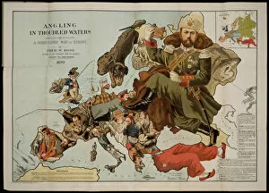
Angling in Troubled Waters. A Serio-Comic Map of Europe. Artist: Fred W. Rose (active End of 19th cen. )Angling in Troubled Waters. A Serio-Comic Map of Europe. Private Collection
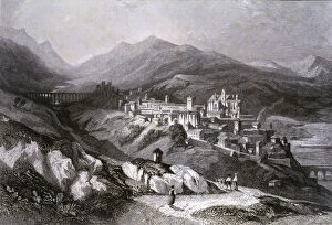
View of the city of Plasencia (Caceres), engraving in Voyage Pittoresque en Espagne et en Portugal, 1840, by Emile Begin
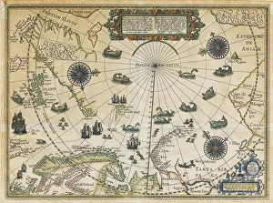
Map of Willem Barentsz Third Voyage, 1598. Artist: Claesz, Cornelis (ca. 1551-1609)Map of Willem Barentsz Third Voyage, 1598. Private Collection
Corner of a Library, 1711. Creator: Jan van der HeydenCorner of a Library, 1711. An interior set against a plain wall with a bookcase to one side on which are neatly arranged volumes in perfect order
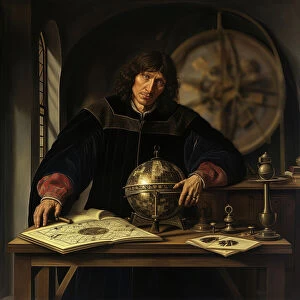
AI IMAGE - Portrait of Nicolaus Copernicus, early 16th century, (2023). Creator: Heritage ImagesAI IMAGE - Portrait of Nicolaus Copernicus, early 16th century, (2023). Copernicus (1473-1543) was a Polish Renaissance polymath, active as a mathematician, astronomer, and Catholic canon
Trompe l'oeil with prints, maps and publications, in or after 1748. Creator: AnonTrompe l'oeil with prints, maps and publications, in or after 1748. Against a background of woven fabric
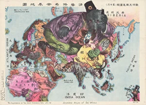
The Illustration of the Great European War. A satirical Atlas of the World, 1914. Creator: Tanaka, Ryozo (1874-1946)The Illustration of the Great European War. A satirical Atlas of the World, 1914. Private Collection
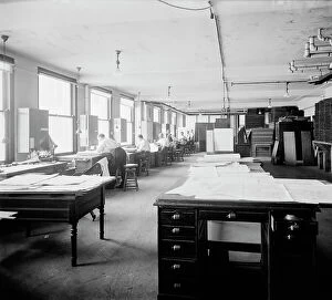
Geological Survey art room, between 1910 and 1920. Creator: Harris & EwingGeological Survey art room, [Washington, DC], between 1910 and 1920. [Map-making]
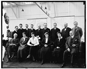
Red Cross Group, between 1910 and 1920. Creator: Harris & Ewing. Red Cross Group, between 1910 and 1920Red Cross Group, between 1910 and 1920. Group of men and women, with maps of the world and The Philippine Islands
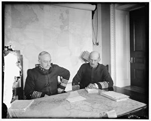
Benson and Mayo, between 1910 and 1920. Creator: Harris & Ewing. Benson and Mayo, between 1910 and 1920Benson and Mayo, between 1910 and 1920. US admirals William Shepherd Benson and Henry Thomas Mayo looking at a map of Mexico. Notepaper headed Office of Naval Operations'
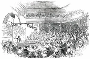
Royal Institution - Sir Roderick Murchison's Lecture on the Distribution of Gold Ore, 1850. Creator: UnknownRoyal Institution - Sir Roderick Murchison's Lecture on the Distribution of Gold Ore, 1850. Geological talk in London
View of London from Greenwich, 1825. Creator: JMW TurnerView of London from Greenwich, 1825
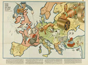
Hark! Hark! The Dogs Do Bark! European satirical map, 1914. Artist: AnonymousHark! Hark! The Dogs Do Bark! European satirical map, 1914. Private Collection
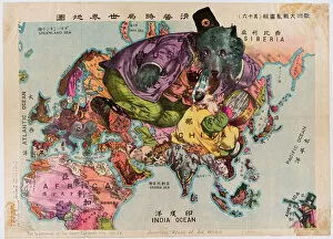
Japanese Map from 1914. A satirical Atlas of the World. Private Collection
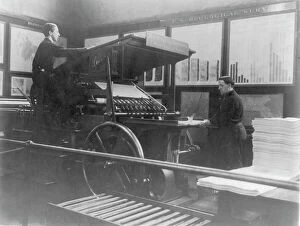
2 men operating map printing press at U.S. Geol. Survey, (1900?). Creator: Frances Benjamin Johnston2 men operating map printing press at U.S. Geol. Survey, (1900?)
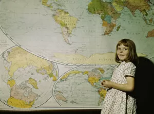
Rural school girl, San Augustine County, Texas, 1943. Creator: John VachonRural school girl, San Augustine County, Texas
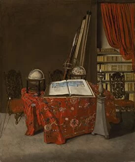
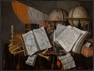
A Vanitas Still Life with a Flag, Candlestick, Musical Instruments, Books, Writing Paraphernalia, Globes and Hourglass, 1662
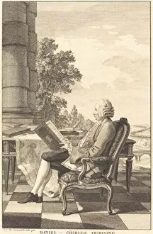
Daniel-Charles Trudaine, c. 1761. Creator: UnknownDaniel-Charles Trudaine, c. 1761
Man of Science, 1839. Creator: UnknownMan of Science, 1839
Atlas of Borso d Este, ca 1466-1467. Creator: Germanus, Donnus Nicolaus (ca. 1420-caAtlas of Borso d Este, ca 1466-1467. Found in the collection of Biblioteca Estense Universitaria, Modena
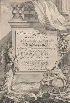
Trade Card for Thomas Jefferys, Engraver, Geographer, and Printseller, 18th century
Captain Charles Stewart, 1811-1812. Creator: Thomas SullyCaptain Charles Stewart, 1811-1812
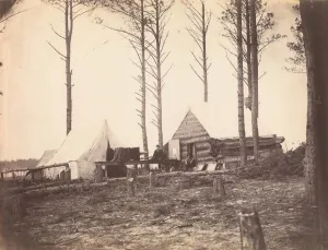
Copying Maps, Photographic Headquarters, Petersburg, Virginia, March 1865
Head Runner or Runaways from the Leipzic Fair, March 2, 1814. March 2, 1814Head Runner or Runaways from the Leipzic Fair, March 2, 1814
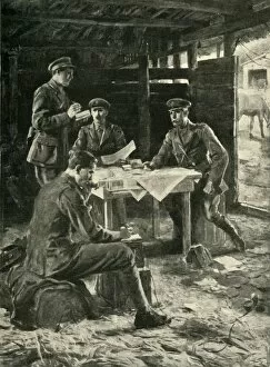
British officers on the Western Front, First World War, 1914-1918, (c1920). Creator: M UgoBritish officers on the Western Front, First World War, 1914-1918, (c1920). Directing an Attack on the British Front: scene at a brigade head-quarters
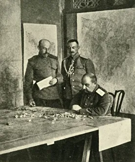
General Nikolai Yudenich, First World War, 1914-1918, (c1920). Creator: UnknownGeneral Nikolai Yudenich, First World War, 1914-1918, (c1920). The Grand Dukes Master Strategist: General Judenich, who planned the Russian campaigns in Asia Minor, Persia, and Mesopotamia
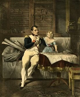
Le Cabinet de Napoleon, 19th century, (1921). Creator: UnknownLe Cabinet de Napoleon, 19th century, (1921). Napoleons Office. The emperor Napoleon and a child look at maps and discuss military strategy
Map of South America where the Plata River is seen, 1530 - 1535, Table 22 from the Atlas Mediceo
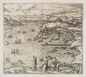
View of the city of Santander. Engraving for the work Civitates Orbis Terrarrum, 1576, by George Braun with drawings by Frans Hoenberg and engravings by George Hoefnagel
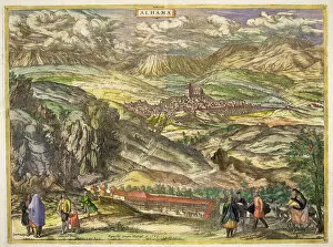
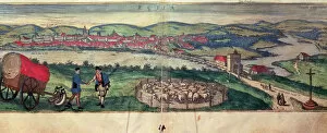
View of the town of Alhama (Granada). Engraving for the work Civitates Orbis Terrarrum, 1576, by George Braun with drawings by Frans Hoenberg and engravings by George Hoefnagel
View of the city of Bilbao. Engraving of 1544 for the play Civitates Orbis Terrarrum, 1576, by George Braun with drawings by Frans Hoenberg and engravings by George Hoefnagel
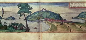
View of the city of San Sebastian. Engraving in Civitates Orbis Terrarum, 1576 by George Braun with drawings by Frans Hoenberg and engravings by George Hoefnagel
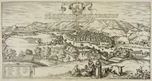
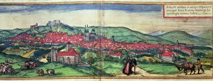
View of the city of Burgos. Engraving in the work Civitates Orbis Terrarrum, 1576, by George Braun with drawings by Frans Hoenberg and engravings by George Hoefnagel
View of the city of Ecija and the Genil river. Engraving in the work Civitates Orbis Terrarum, by George Braun, 1576, with drawings by Frans Hoenberg and engravings by George Hoefnagel
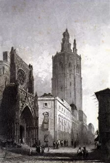
View of the Cathedral and the Miquelet tower in Valencia, engraving in Voyage Pittoresque en Espagne et en Portugal, 1840, by Emile Begin
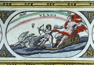
Venus, colored engraving from the book Le Theatre du monde or Nouvel Atlas, 1645, created, printed and published in Amsterdam by William and Jean Bleau
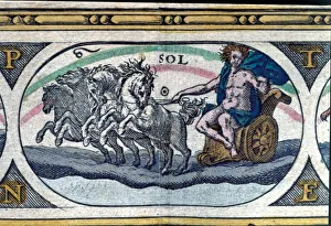
The sun, colored engraving from the book Le Theatre du monde or Nouvel Atlas, 1645, created, printed and published in Amsterdam by William and Jean Bleau
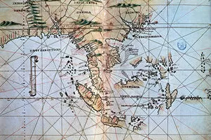
Asian South East in the Islario General del Mundo, of 1560, work by the cronist and cosmographer Alonso de Santa Cruz
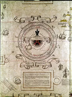
Windrose, line of the tropics and the equator by de Diego Rivero, cosmographer, copy of the Royal Census of the Casa de Contratacion in Sevilla, 1529
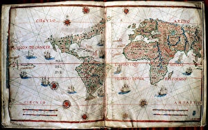
Planisphere of the work Summa of Cosmographia, 1545, by Pedro de Medina
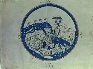
General map of the known world, from the work Manuscript Pocock (Recreation for people who wish to tour countries), edition of 1456 printed in The Cairo
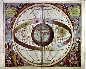
Macrocosm Harmony, engraving in the work Scenographia systematis mundani ptolemaici, 1661
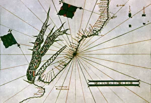
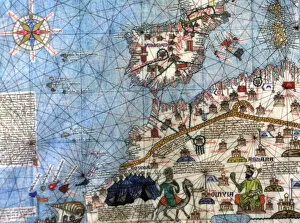
Catalan Atlas (1375). Detail of Spain and North Africa. Reproduction of the original which is located in the National Library in Paris
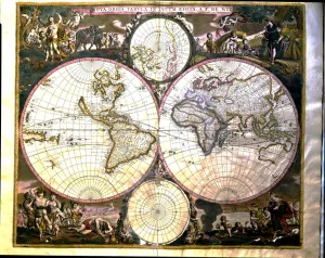
World map in Atlas by Frederik de Wit