mail_outline sales@mediastorehouse.com
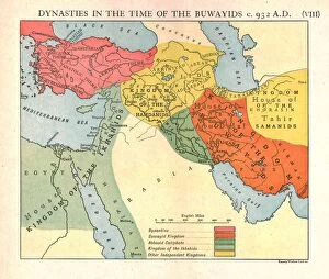
Dynasties in the time of the Buwayids, circa 932 A. D. c1915. Creator: Emery Walker LtdDynasties in the time of the Buwayids, circa 932 A.D. c1915. Map of civilisations in the Middle East during the 10th century: Byzantine, Buwayid Kingdom, Abbasid Caliphate, Kingdom of the Ikhshids
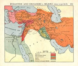
Byzantine and Crusaders v. Seljuks, circa 1130 A. D. c1915. Creator: Emery Walker LtdByzantine and Crusaders v. Seljuks, circa 1130 A.D. c1915. Map of civilisations in the Middle East during the 12th century: Byzantine, other Christian states, Abbasid Caliphate, Seljuks, Fatimids
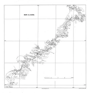
Neri to Akra, c1915. Creator: Stanfords Geographical EstablishmentNeri to Akra, c1915. Map showing the journey of British writer, soldier and diplomatic advisor Mark Sykes in Turkey, (at that time part of the Ottoman Empire)
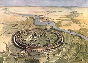
Baghdad in the Days of Mansur, 1915. Creator: Edmund SandarsBaghdad in the Days of Mansur, 1915. Aerial view of the walled city of Baghdad (modern-day Iraq) as it might have appeared in the 8th century AD
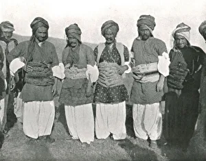
Girdi Kurds, c1906-1913, (1915). Creator: Mark SykesGirdi Kurds, c1906-1913, (1915). Kurdish men, possibly from Girdi Abdulaziz, (Erbil Governorate, Kurdistan Region of Iraq)
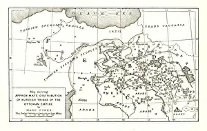
Map showing Approximate Distribution of Kurdish Tribes of the Ottoman Empire, c1915. Diagram by British writer, soldier and diplomatic advisor Mark Sykes (1879-1919)
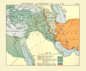
Ottoman and Persian, after 1450 A. D. c1915. Creator: Emery Walker LtdOttoman and Persian, after 1450 A.D. c1915. Map of empires in the Middle East during the 15th-17th centuries: Ottoman Empire at the accession of Mohammed II, 1451 AD, Additions 1481-1683
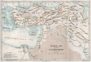
Physical Map of the Ottoman Empire, c1915. Creator: UnknownPhysical Map of the Ottoman Empire, c1915. Map showing the eastern Mediterranean, Cyprus, the Middle East, the rivers Tigris and Euphrates, what is now Turkey, and part of Egypt
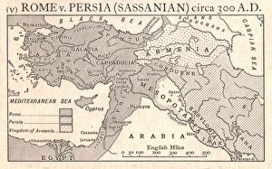
Rome v. Persia (Sassanian), circa 300 A. D. c1915. Creator: Emery Walker LtdRome v. Persia (Sassanian), circa 300 A.D. c1915. Map of the eastern Mediterranean and Near East, showing the ancient empires of Rome, Persia, and Armenia
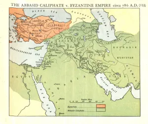
The Abbasid Caliphate v. Byzantine Empire, circa 786 A. D. c1915. Creator: Emery Walker LtdThe Abbasid Caliphate v. Byzantine Empire, circa 786 A.D. c1915. Map of civilisations in the Middle East during the 8th century, and also showing the eastern Mediterranean, Red Sea, Caspian Sea
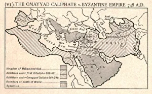
The Omayyad Caliphate v. Byzantine Empire, circa 748 A. D. c1915. Creator: Emery Walker LtdThe Omayyad Caliphate v. Byzantine Empire, circa 748 A.D. c1915. Map of the Mediterranean and Near East, showing the Kingdom of Mohammed, Additions under the Caliphs
Sixth Form Bench, and Fellows Eyot, 1911. Creator: UnknownSixth Form Bench, and Fellows Eyot, 1911. Fellows Eyot is a riverside field from which the Procession of Boats from Eaton can be viewed on the 4th June
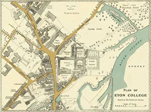
Plan of Eton College, 1911. Creator: UnknownPlan of Eton College, 1911. Generations of British and foreign aristocracy have been educated at Eton independent boarding school, founded in 1440 by King Henry VI
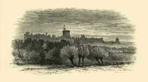
Windsor Castle from the Provosts Lodge at Eton, 1911. Creator: UnknownWindsor Castle from the Provosts Lodge at Eton, 1911. Eton College, a royal foundation of Henry VI is located half a mile from Windsor Castle, built in the 11th century
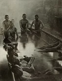
A Public Bath at Kanawa, 1910. Creator: Herbert PontingA Public Bath at Kanawa, 1910. From " In Lotus-Land Japan", by Herbert G. Ponting, F.R.G.S. [Macmillan and Co. Limited, London, 1910]
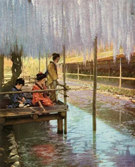
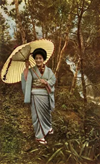
Under the Purple Wistarias, 1910. Creator: Herbert PontingUnder the Purple Wistarias, 1910. From " In Lotus-Land Japan", by Herbert G. Ponting, F.R.G.S. [Macmillan and Co. Limited, London, 1910]
A Cloisonne Vase for the Emperor, 1910. Creator: Herbert PontingA Cloisonne Vase for the Emperor, 1910. An artisan working during the Meiji Era (1868-1912). From " In Lotus-Land Japan", by Herbert G. Ponting, F.R.G.S. [Macmillan and Co
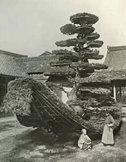
The Pine-Tree Junk at Kinkakuji, 1910. Creator: Herbert PontingThe Pine-Tree Junk at Kinkakuji, 1910. From " In Lotus-Land Japan", by Herbert G. Ponting, F.R.G.S. [Macmillan and Co. Limited, London, 1910]
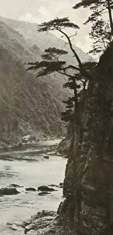
A Glen on the Katsura-Gawa, 1910. Creator: Herbert PontingA Glen on the Katsura-Gawa, 1910. From " In Lotus-Land Japan", by Herbert G. Ponting, F.R.G.S. [Macmillan and Co. Limited, London, 1910]
A Shower in the Woods, 1910. Creator: Herbert PontingA Shower in the Woods, 1910. From " In Lotus-Land Japan", by Herbert G. Ponting, F.R.G.S. [Macmillan and Co. Limited, London, 1910]
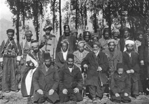
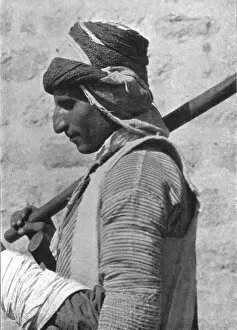
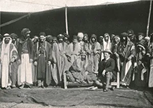
Shaykh Hamid Pasha, c1906-1913, (1915). Creator: Mark SykesShaykh Hamid Pasha, c1906-1913, (1915). Group portrait of a sheikh and his retinue, in a village...which is situated perhaps two and half miles outside Bashkala
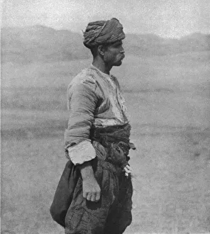
Kurd of Neri, c1906-1913, (1915). Creator: Mark SykesKurd of Neri, c1906-1913, (1915). Profile portrait of a Kurdish man from what is now eastern Turkey. From " The Caliphs Last Heritage, a short history of the Turkish Empire" by Lt.-Col
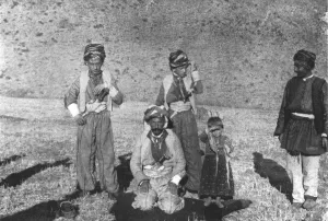
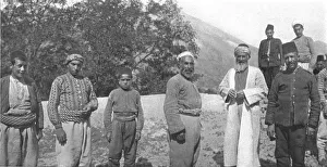
Musa Bey el Abbasieh, c1906-1913, (1915). Creator: Mark SykesMusa Bey el Abbasieh, c1906-1913, (1915). Group of people in Central Asia, probably in what is now Turkey. From Diza we proceeded to Gulanik
Kastamuni Peasant showing Gallic Type, c1906-1913, (1915). Creator: Mark SykesKastamuni Peasant showing Gallic Type, c1906-1913, (1915). Man wearing a turban, possibly from Kastamonu, (Turkey). From " The Caliphs Last Heritage
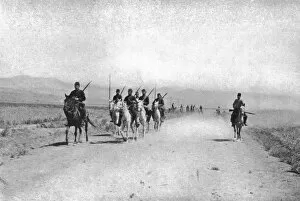
Cavalry Patrol near Erzinjan, c1906-1913, (1915). Creator: Mark SykesCavalry Patrol near Erzinjan, c1906-1913, (1915). Mounted men in the valley of Erzinjan in Anatolia, (Turkey). From " The Caliphs Last Heritage
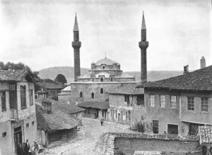
Tosia, c1906-1913, (1915). Creator: Mark SykesTosia, c1906-1913, (1915). View of mosque and minarets in...the small town of Tosia, [Turkey?], in which there is nothing remarkable
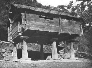
House near Ayundun, c1906-1913, (1915). Creator: Mark SykesHouse near Ayundun, c1906-1913, (1915). Timber building on stone piers, possibly to prevent rodents. From Istifan we proceeded by horse to Ayundun [Turkey
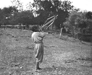
Boy with a Cross Bow at Sinope, c1906-1913, (1915). Creator: Mark SykesBoy with a Cross Bow at Sinope, c1906-1913, (1915). Boy using a crossbow, Sinop, (Turkey). From " The Caliphs Last Heritage, a short history of the Turkish Empire" by Lt.-Col
Ak Koyunlu Turks, c1906-1913, (1915). Creator: Mark SykesAk Koyunlu Turks, c1906-1913, (1915). A group of men in Avrik, (Iraq?): we are the Ak Koyunlu Turks of Uzun Hassan. The Aq Qoyunlu (or Ak Koyunlu), also called the White Sheep Turkomans
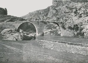
The Roman Bridge at Solali, c1906-1913, (1915). Creator: Mark SykesThe Roman Bridge at Solali, c1906-1913, (1915). Ancient bridge which...stands at the entrance of a short but chasm-like gorge, which leads the Diarbekir Su into the open valleys of the Sus district
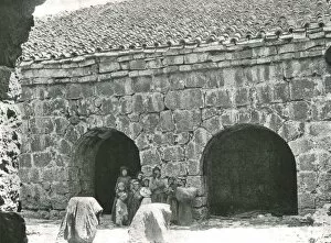
Deir Amar, c1906-1913, (1915). Creator: Mark SykesDeir Amar, c1906-1913, (1915). Women and children outside traditional stone houses in the village of Deir al-Qamar, (Lebanon)
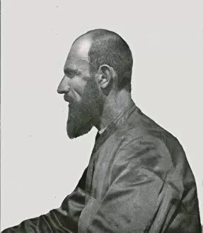
Armenian Priest at Dibneh, c1906-1913, (1915). Creator: Mark SykesArmenian Priest at Dibneh, c1906-1913, (1915). Portrait of a an orthodox Christian priest in the village of Dibneh, (Iraq)
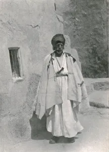
Yezidi Shaykh of Sinjar, c1906-1913, (1915). Creator: Mark SykesYezidi Shaykh of Sinjar, c1906-1913, (1915). Yazidi (or Yezidi) sheikh from Sinjar, (northern Iraq). From " The Caliphs Last Heritage, a short history of the Turkish Empire" by Lt.-Col
Ibrahim Pasha, c1906-1913, (1915). Creator: Mark SykesIbrahim Pasha, c1906-1913, (1915). From " The Caliphs Last Heritage, a short history of the Turkish Empire" by Lt.-Col. Sir Mark Sykes. [Macmillan & Co, London, 1915]
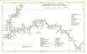
Route between Karaman and Kiz Kale, c1915. Creator: Stanfords Geographical EstablishmentRoute between Karaman and Kiz Kale, c1915. (Note Boyalar is about 8 miles S. of Karaman). Map showing the journey of British writer
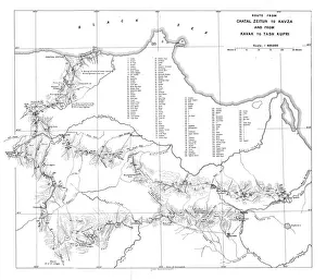
Route from Chatal Zeitun to Kavza and from Kavak to Tash Kupri, c1915. Creator: UnknownRoute from Chatal Zeitun to Kavza and from Kavak to Tash Kupri, c1915. Map showing the journeys of British writer, soldier and diplomatic advisor Mark Sykes in northern Turkey
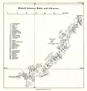
Sketch between Balat and Adranos, c1915. Creator: Stanfords Geographical EstablishmentSketch between Balat and Adranos, c1915. Map showing the journey of British writer, soldier and diplomatic advisor Mark Sykes between Balat and Adranos in Turkey
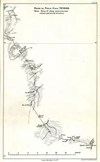
Route to Petra from Teyaha, c1915. Creator: Stanfords Geographical EstablishmentRoute to Petra from Teyaha, c1915. (Note: None of these watercourses contain perennial streams). Map showing the journey of British writer
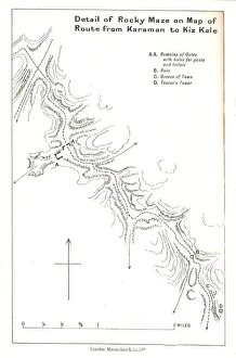
Detail of Rocky Maze on Map of Route from Karaman to Kiz Kale, c1915. Map showing part of the journey of British writer, soldier and diplomatic advisor Mark Sykes between Karaman (in Central Anatolia)
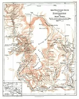
The Western Bend of the Euphrates, c1915. Creator: Mark SykesThe Western Bend of the Euphrates, c1915. Map of the River Euphrates and surrounding areas. From " The Caliphs Last Heritage, a short history of the Turkish Empire" by Lt.-Col
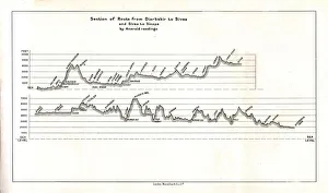
Section of Route from Diarbekir to Sivas and Sivas to Sinope by Aneroid readings, c1915. Map showing the journeys, with altitude above sea level, of British writer
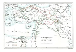
Authors Routes in Asiatic Turkey, c1915. Creator: Stanfords Geographical EstablishmentAuthors Routes in Asiatic Turkey, c1915. Map showing the journeys of British writer, soldier and diplomatic advisor Mark Sykes (1879-1919) who travelled through Palestine, Iraq, Syria
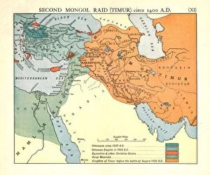
Second Mongol Raid (Timur), circa 1450 A. D. c1915. Creator: Emery Walker LtdSecond Mongol Raid (Timur), circa 1450 A.D. c1915. Map of civilisations in the Middle East during the 14th and 15th centuries: Ottomans c1350 AD, Ottoman Empire in 1400 AD
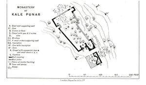
Monastery at Kale Punar, c1915. Creator: Stanfords Geographical EstablishmentMonastery at Kale Punar, c1915. Plan of monastic buildings in Turkey, at that time part of the Ottoman Empire, showing chapels, cisterns, caves and fountains
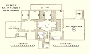
Bath built by Sultan Bayezid I, circa 1390 A.D. at Mudurlu, c1915. Plan of baths supposedly built by the Ottoman sultan Bayezid I, showing the tank, mens and womens cooling rooms
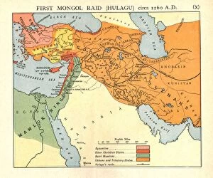
First Mongol Raid (Hulagu), circa 1400 A. D. c1915. Creator: Emery Walker LtdFirst Mongol Raid (Hulagu), circa 1400 A.D. c1915. Map of civilisations in the Middle East during the early 15th century: Byzantine, other Christian states, Bahri Mamluks
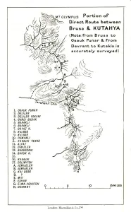
Portion of direct route between Brusa and Kutahya, c1915. (Note: from Brusa to Osauk Punar & from Devrant to Kutakia is accurately surveyed)
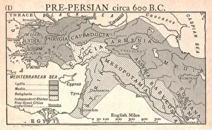
Pre-Persian, circa 600 B. C. c1915. Creator: Emery Walker LtdPre-Persian, circa 600 B.C. c1915. Map of the eastern Mediterranean and near East, showing the ancient civilisations of empires of Lydia, Media, Babylonia, Independent States, and free Greek cities